01.30.11
Posted in Non-US Weather, Tropical Weather, Weather Forecast at 1:46 pm by Rebekah
As if Queensland hasn’t already seen enough rain and flooding to last a lifetime, a new tropical cyclone is forming in the southeast Pacific, and models show it strengthening to possibly a Category 3 (Australian) cyclone (probably only Cat. 1 on the Saffir-Simpson scale) just before making landfall somewhere near or south of Townsville, Queensland on Thursday.
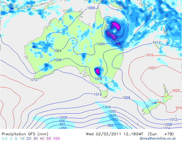
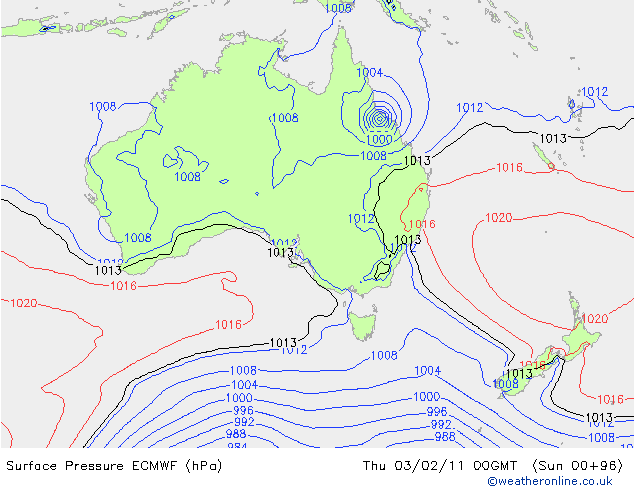
This tropical cyclone, Yasi (on the Fiji names list), may bring 70+ mph (110+ kph) winds and heavy rain when it makes landfall. The GFS model is currently predicting a minimum pressure of 976 mb, while the ECMWF is predicting a minimum pressure of 972 mb, with a slightly faster track.
Here’s the GFS model’s forecast (from Weather Online UK) for surface pressure and precipitation, at 18Z on Wednesday (4 am Thursday, local time)…the cyclone is predicted to make landfall about 6 hours later:

Here’s an ECMWF forecast for surface pressure, for comparison…the nearest time they have is for Thursday at 00Z (10 am Thursday, local time):

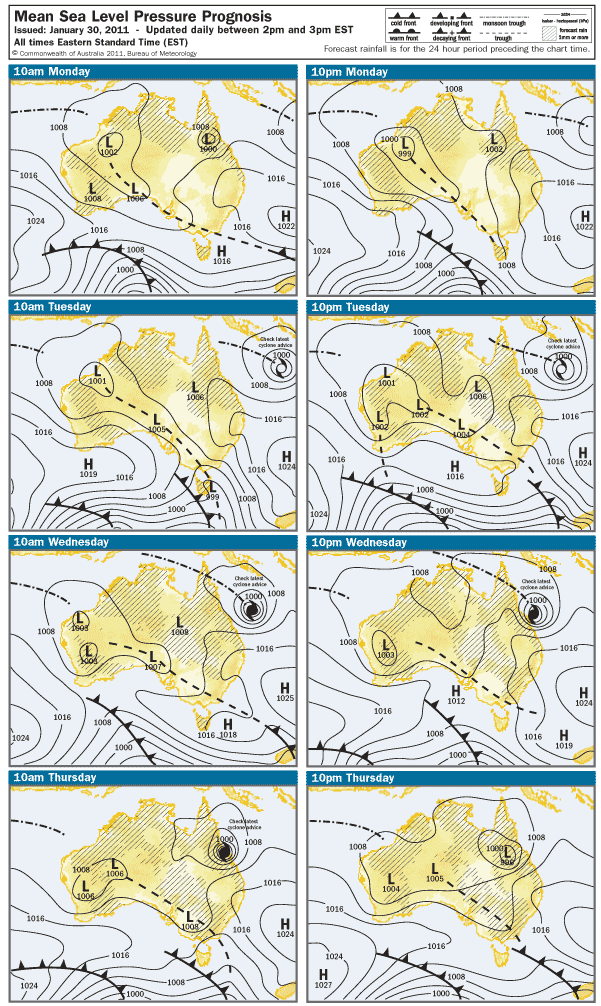
Here’s what the Australian Bureau of Meteorology is predicting for the next few days (for those of you in the U.S., the local “Eastern Standard Time” on this map is 15 hours ahead of the U.S. Eastern Standard Time):

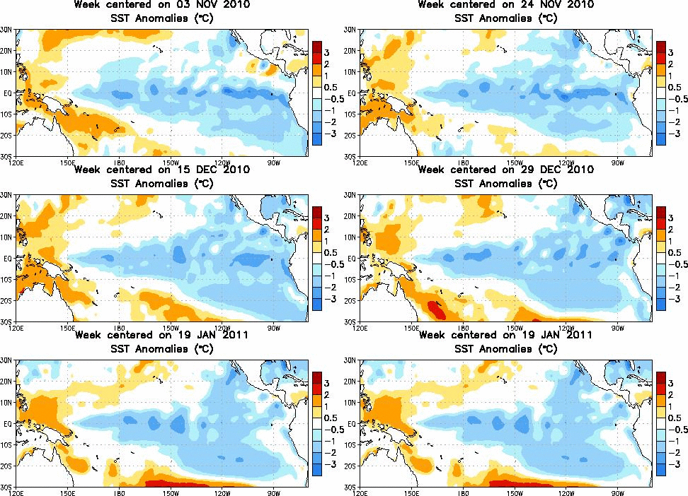
Waters off the eastern coast of Queensland are warmer-than-normal, aiding in the strengthening of Yasi just before landfall.
Tropical sea-surface temperature anomalies, from the Climate Prediction Center:

Here’s another link, from NCDC, showing sea-surface temperature anomalies across the entire globe over the past 5 weeks.
Permalink
Posted in Weather News, Winter Weather at 8:00 am by Rebekah
For quite some time now the models have been hinting at the possibility for a decent amount of snow and possibly ice for Oklahoma this week. The models have come to some sort of agreement lately and it’s looking like parts of central to northern Oklahoma could see several inches of snow from Monday night into Tuesday.
There may be some sleet or even freezing rain Monday night as well, but the GFS and the NAM aren’t showing much of a warm layer, if any.
A strong, arctic high (could be as high as 1048 mb or so) will edge down into the Northern Plains, bringing frigid air along with it. The National Weather Service in Norman (Oklahoma) is calling for a low of 7 °F in Norman Tuesday night.
We could certainly use some precipitation…it’s been so dry in the Southern Plains, and numerous fires have broken out in the last couple of days.
These last two days have been nice in terms of temperature, though; yesterday Norman reached 79 °F and today 76 °F! 🙂 I still haven’t turned my heat on…I haven’t had the heat on since March, if not February of 2010. My apartment stays insulated pretty well and so far this winter it hasn’t stayed cold for longer than a couple of days.
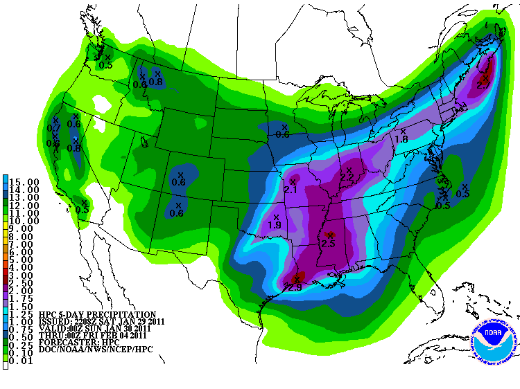
Here’s the 5-day precipitation (liquid-water equivalent) forecast from the Hydrometeorological Prediction Center…looks like it could be wet for much of the U.S. this week!

Permalink
01.29.11
Posted in Non-US Weather, Tropical Weather, Weather News at 8:00 am by Rebekah
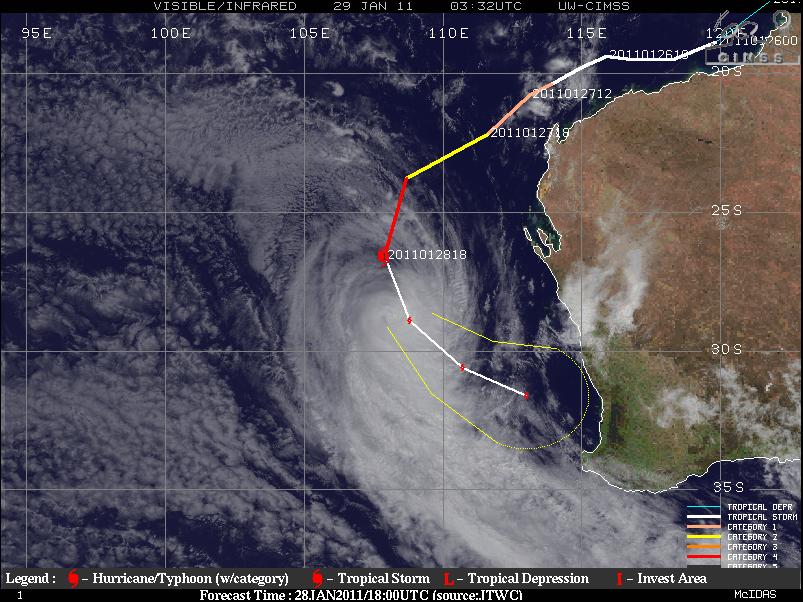
Severe Tropical Cyclone Bianca, a weakening Category 3 tropical cyclone on the Australian rating system (Category 1 on the Saffir-Simpson Scale), has been taking a very strange trek along the western coast of Australia.

Satellite image, history, and forecast track of Bianca along Australia’s west coast. Source: CIMSS
Note how Bianca formed off the northwestern coast of Australia and proceeded to move almost parallel to the coast, all the way down to the southwestern coast, where the cyclone is expected to make landfall on Sunday.
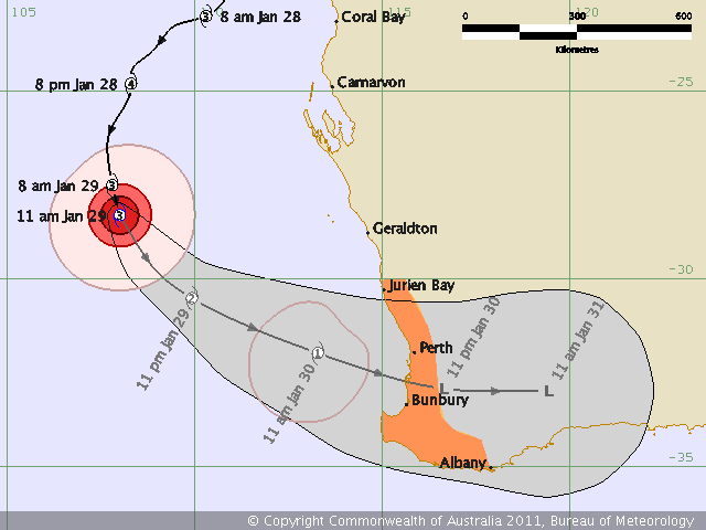
Bianca’s maximum sustained winds are about 75 to 85 mph, but she is expected to keep weakening as she encounters cooler water temperatures and increased wind shear. The center of the cyclone is forecast to make landfall just south of Perth as a weak Aus. Cat. 1 (tropical storm on the SS-scale) or tropical low (tropical depression). Primary threats to the coast will be rough seas, heavy rainfall with possibly some localized flooding, and strong wind gusts up to about 60 mph.

Bianca’s history and forecast track, as of Saturday morning Australian Western Standard Time, from the Australian Bureau of Meteorology

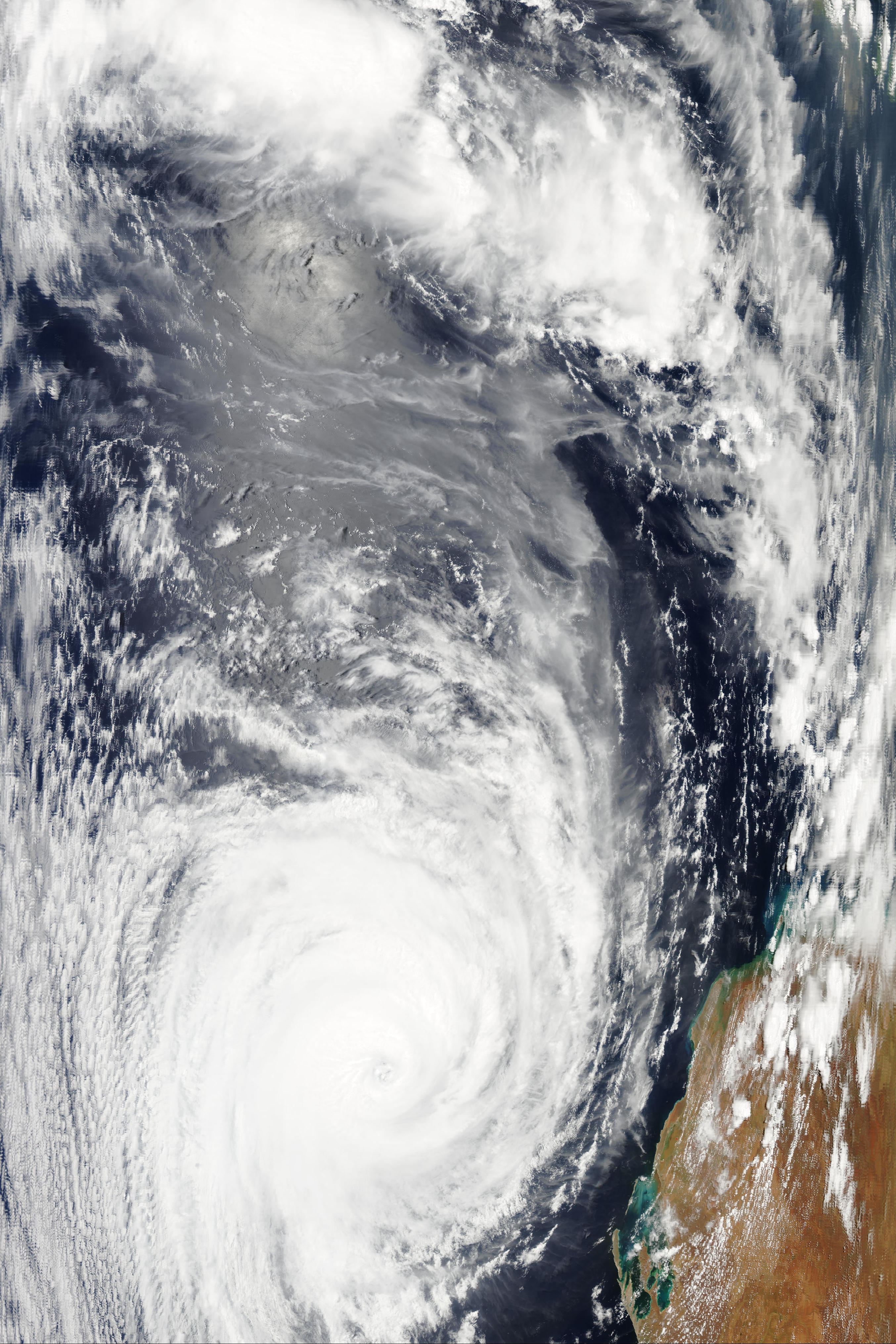
Bianca (click to enlarge), at 6:30 UTC on the 28th, via NASA’s Aqua/MODIS satellite (looks more impressive than the more recent image from early on the 29th…go to the “real-time” tab to see the latest images)
As a follow up to my post on Severe Tropical Cyclone Wilma the other day, Wilma is now only a shadow of her former self…the cyclone brushed past the northern coast of New Zealand, and now is just a low falling apart southeast of New Zealand.
For the latest on Tropical Cyclone Bianca, check out the Australian Bureau of Meteorology, Weather Underground, and CIMSS. To learn about tropical cyclone ratings in different ocean basins, check out the chart on this older blog post of mine.
Permalink
01.28.11
Posted in Winter Weather at 8:00 am by Rebekah
The Knickerbocker Storm was a blizzard that took place along the mid-Atlantic U.S. coast on January 27 – 28, 1922.
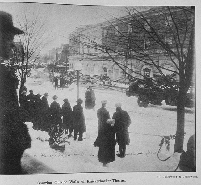
The blizzard was known for the collapse of the Knickerbocker Theatre in Washington, D.C., under the weight of heavy snow. Tragically, 98 people were killed and 133 injured when the cinema’s roof caved in.

The Knickerbocker Theater, following its collapse. Source: NOAA
Meteorological Synopsis
Nearly a week prior to the event, a sub-freezing airmass set in across the Northeast and mid-Atlantic.
A low formed off the coast of Georgia, and rapidly deepened as it began to move up the coast. A strong high pressure system in southeastern Canada prevented the low from moving northward very fast, so it took three days for it to travel up the East Coast, prolonging the event.
On the 27th, heavy snow started to fall from the Carolinas to Pennsylvania with the low off the North Carolina coast. The hardest-hit areas were from Washington, D.C. to Philadelphia. Snow fell in Washington from about noon on the 28th until the morning of the 29th. Snow totals in the city ranged from 28 to 33 inches. This went down as the biggest snowstorm in Washington since official records began in 1885.

Weather Bureau map from the morning of January 28, 1922. Source: NOAA
Impacts
Parts of the Northeast received 20 or more inches of snow, while much of the rest of the Eastern Seaboard received at least 4 inches. Some snow drifts on railroad lines between Philadelphia and Washington were as high as 16 feet.
The Knickerbocker Theatre in Washington, D.C. was just 5 years old and was the biggest cinema in town. The roof was flat, allowing the wet, heavy snow to accumulate and eventually force the roof to collapse. The balcony section came down as well, and dozens of people were buried. Hundreds of rescue workers came to help, some of them comparing the scene to one from World War I. This disaster ranks as one of the worst in Washington’s history.
Permalink
01.27.11
Posted in Non-US Weather, Tropical Weather, Weather News at 8:00 am by Rebekah
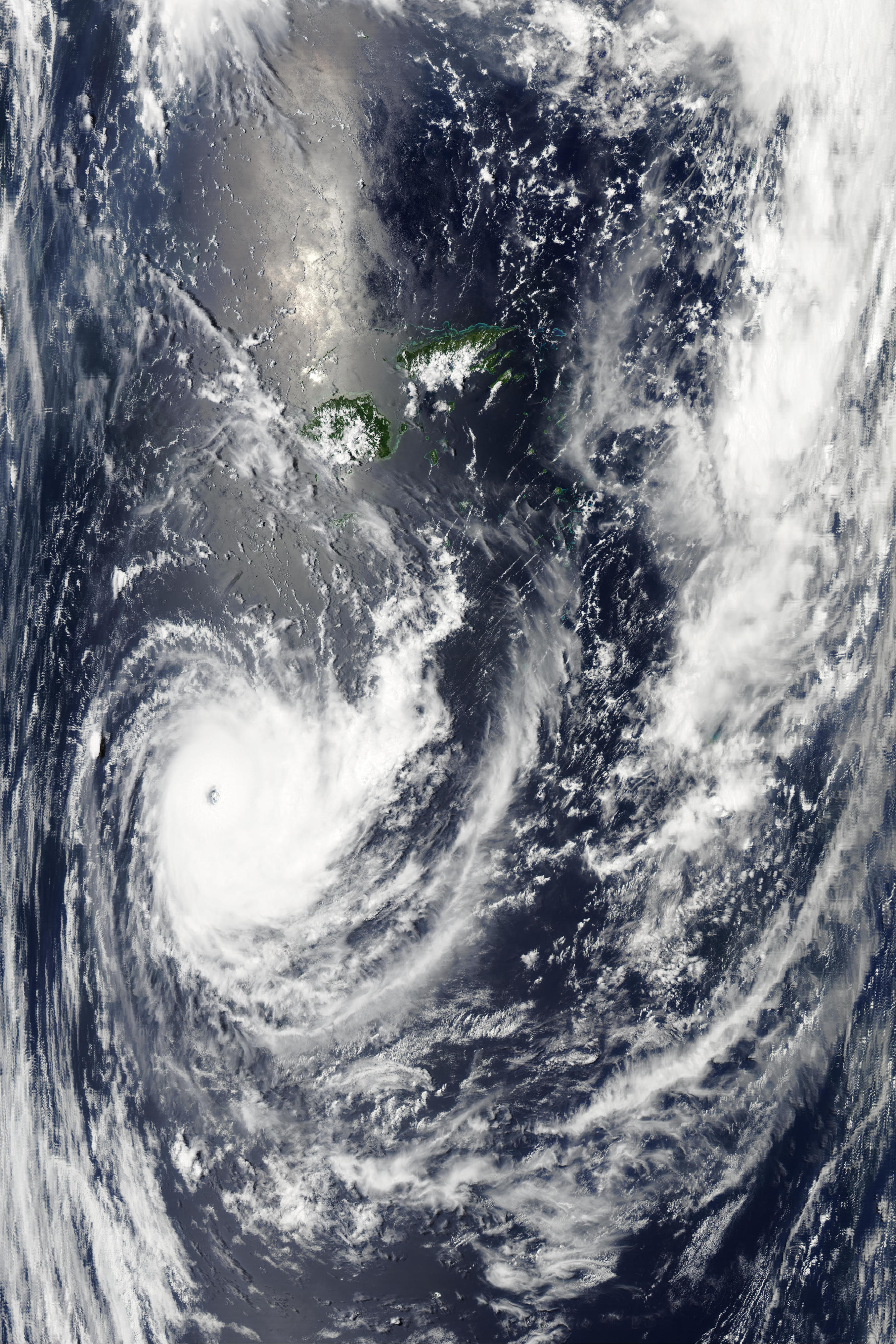
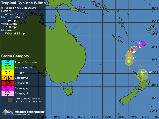
Severe Tropical Cyclone Wilma, the equivalent of a Category 3 (borderline Category 4) hurricane (as of Wednesday night) on the Saffir-Simpson scale, is about a thousand miles north of the northern island of New Zealand. As of Wednesday night, Wilma’s maximum winds were estimated at 130 mph (gusts to 160 mph). The tropical cyclone is moving west-southwest at about 13 mph, and is expected to make a gradual turn on Friday and may brush the northern coast of the northern island of New Zealand as a tropical storm on Saturday (if she holds together that long).

Aqua/MODIS image of Tropical Cyclone Wilma at 01:45 UTC…to zoom in to as much as 250 m resolution, see the NASA MODIS website, scroll down to the Aqua images from the 26th, and look towards the bottom right for 01:45 UTC.

Wilma’s forecast track via Weather Underground
Permalink
« Previous Page — « Previous entries « Previous Page · Next Page » Next entries » — Next Page »
