08.18.10
Posted in Weather News at 4:11 pm by Rebekah
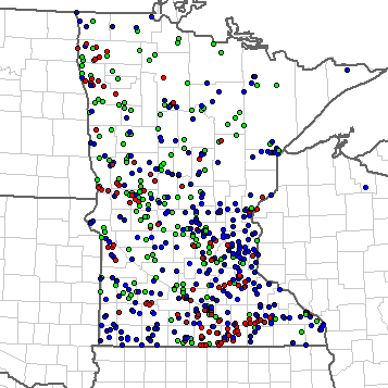
Minnesota has reported 123 tornadoes so far this year, more than any other state.
Texas comes in second, with 87 reported tornadoes.
Annual Severe Weather Report Summary – 2010, Minnesota. Red dots are tornado reports, green hail, wind blue. Courtesy of the SPC.
The most tornadoes in a year in recorded history in Minnesota was 74 in 2001. Not all of these 123 reports will be confirmed as tornadoes; generally the official tornado count is somewhat less than the number of reports, due to multiple reporting of the same tornado or mistakenly reporting a suspicious-looking cloud as a tornado. However, once the National Weather Service completes damage surveys and releases the official numbers next year, 2010 is likely going to break the record for most number of tornadoes in a year in Minnesota (in recorded history).
It is interesting to note that most of these tornadoes came on just a handful of outbreak days, most notably including June 17th (40+). June 17th also broke the record for the most tornadoes in a day in Minnesota history. The previous record was 27 tornadoes on June 16, 1992. Currently, 27 tornadoes have been confirmed with another 15+ likely to be confirmed at a later date. (See NWS Twin Cities report on the event for more.)
One of the reasons for increased tornado reports is the increased number of chasers and spotters observing storms. Also, the storm season didn’t really get going in the Southern Plains until mid- to late April; and by June, the storms had mostly shifted to the Northern Plains (and the season’s still going up there!).
In other news, the U.S. is finally back near the 5-year average for the number of tornado reports.
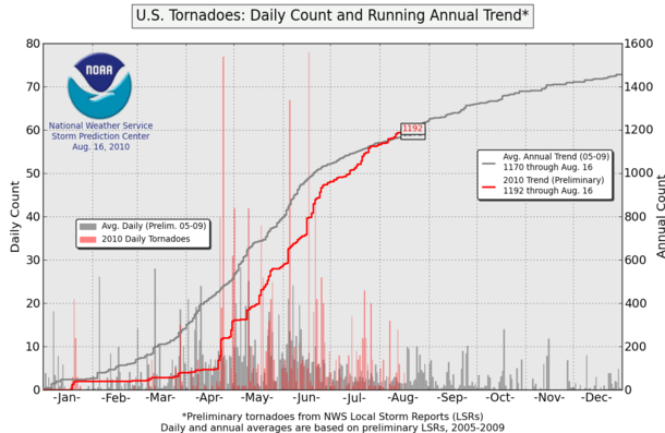
The following plot shows the 2010 running count for tornado reports (remember, the actual number of tornadoes will be less) as compared to the 5-year average annual trend (gray line). The plot also shows the 2010 count and the average count for every day (outbreak days are pretty obvious).
U.S. Tornadoes: Daily Count and Running Annual Trend. Courtesy of the SPC.
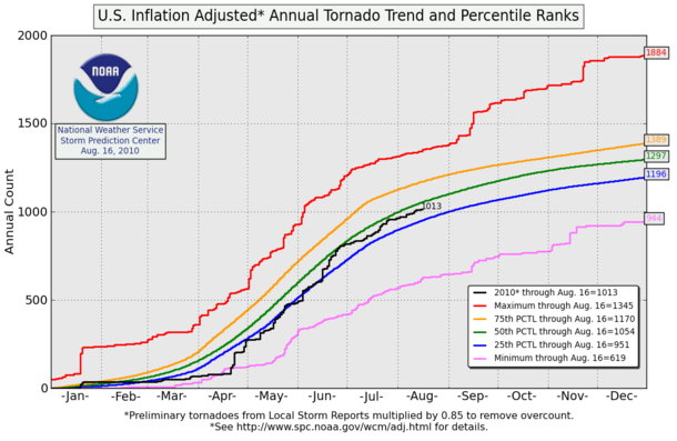
See also the annual tornado trend and percentile ranks as well (below). This plot has been adjusted to account for the overcount of tornadoes (hence “inflation adjusted”). As you can see, we are near the 50th percentile so far (i.e., near average, as the above plot showed too).
U.S. Inflation Adjusted Annual Tornado Trend and Percentile Ranks. Courtesy of the SPC.
Compare these plots with the plots I posted on the blog earlier this year:
April 14: Where Have All The Tornadoes Gone? – (and to think that I was concerned about the lack of tornadoes and chasing opportunities in mid-April…)
May 22: Tornado Season So Far…
For more tornado stats by state and to see what the top 10 active tornado days have been in the U.S. this year, see the SPC’s Annual Weather Report Summary.
Permalink
07.12.10
Posted in Uncategorized at 4:01 pm by Rebekah
Chasing today with Dean and Jeff again; we’re just west of Hays, Kansas, heading westward towards a lone cell south of Goodland. Hoping with some decent shear that it will turn into a supercell and we’ll perhaps get at least some large hail and nice lightning…
Chased yesterday in north central Oklahoma to just northwest of Oklahoma City; saw some very close lightning and torrential rain.
The day before yesterday we also chased in northwest Kansas and saw 1.5-inch hail and some incredible lightning.
Tomorrow we’ll also be chasing somewhere perhaps in north central to northeast Nebraska. For never having chased in July, we’ve been seeing some nice storms and still have (hopefully) even better storms to come, today and tomorrow.
Permalink
07.10.10
Posted in Uncategorized at 7:57 am by Rebekah
Off on my first July storm chase…initial target, Colby, Kansas!
Just hoping for a decent thunderstorm…hopefully a supercell!
You can track me on Spotter Network or on my tracking page on my website.
Permalink
06.15.10
Posted in Severe Weather Forecast at 1:12 pm by Rebekah
On the road again…targeting Texas for the third day in a row. 🙂
(As of the time I am now posting this, 1:10pm, we are between Lawton and Altus on Highway 62, heading west.)
Chase forecast hasn’t changed much the last couple of days…there is less upper-level forcing today, as the trough has lifted. We don’t have very high expectations of today, but again, hard to resist a chase day in west Texas, especially when it could be the last one for a long time.
Long story short, we’re heading down I-44 and then will go out towards Childress (Texas) and perhaps see how far west we can get. Today is a bit tricky as far as determining storm initiation location…yesterday’s storms laid down some outflow boundaries that storms today may form along. There should be some supercells today, but my primary concern at this point is that we may not get to them (at least for a while) as the forecast keeps pushing the storm initiation location further west.
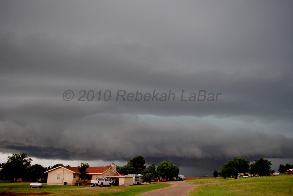
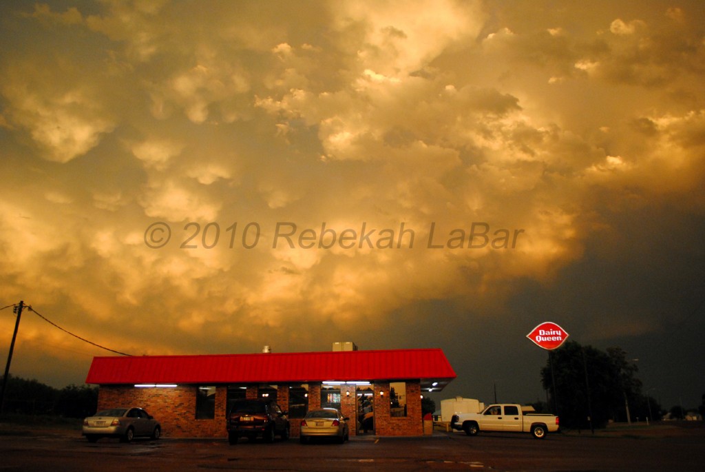
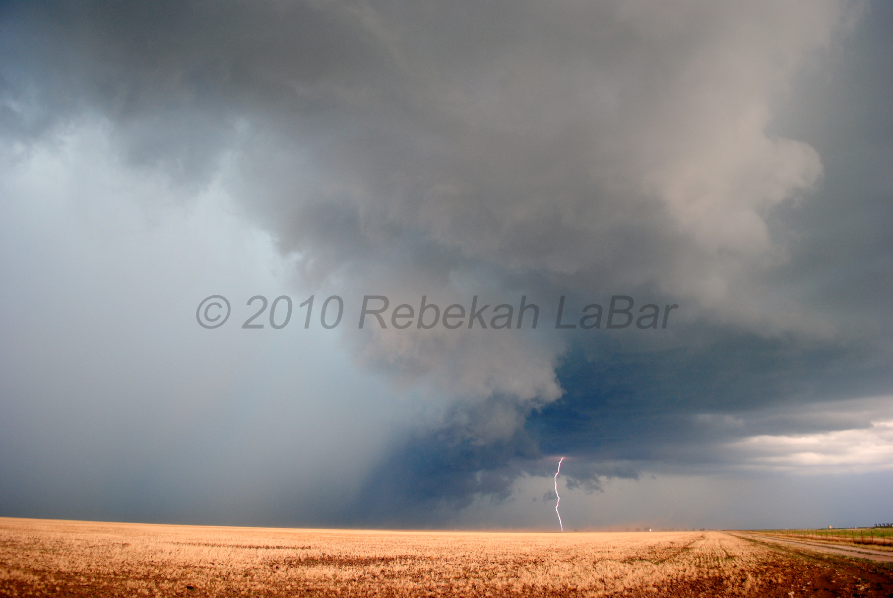
As to yesterday…we drove all over certain parts of west central Texas, chasing a tornado-warned supercell that fell apart as soon as we got on it, chasing another tornado-warned supercell with tennis ball-sized hail that dropped to only quarters when we got on it (did see the most amazing shelf cloud and green sky, though, and got some tiny hail), and later chasing a bow with a great shelf cloud and getting pea-sized hail with extremely strong winds that made my car shudder even as we were parked under shelter. We saw a beautiful sunset with mammatus clouds, and also saw one of the most incredible lightning displays that I have ever seen…the lightning on the way back to Norman (behind the line) was not that frequent, but when we did see it, there were many tendrils that crawled along the underside of the clouds and occasionally touched the ground. We’d see a dozen or more both intra-cloud and cloud-to-ground flashes in one several-second display at a time.
More to come in the chase logs later…I probably won’t be updating the chase logs until I get the new website up, but hopefully that will come as soon as the end of this week!!

Shelf cloud over Guthrie, Texas

Sunset and mammatus clouds over Spur, Texas

Sunset and mammatus clouds over Dairy Queen in Spur, Texas
Permalink
06.14.10
Posted in Severe Weather Forecast at 11:00 am by Rebekah
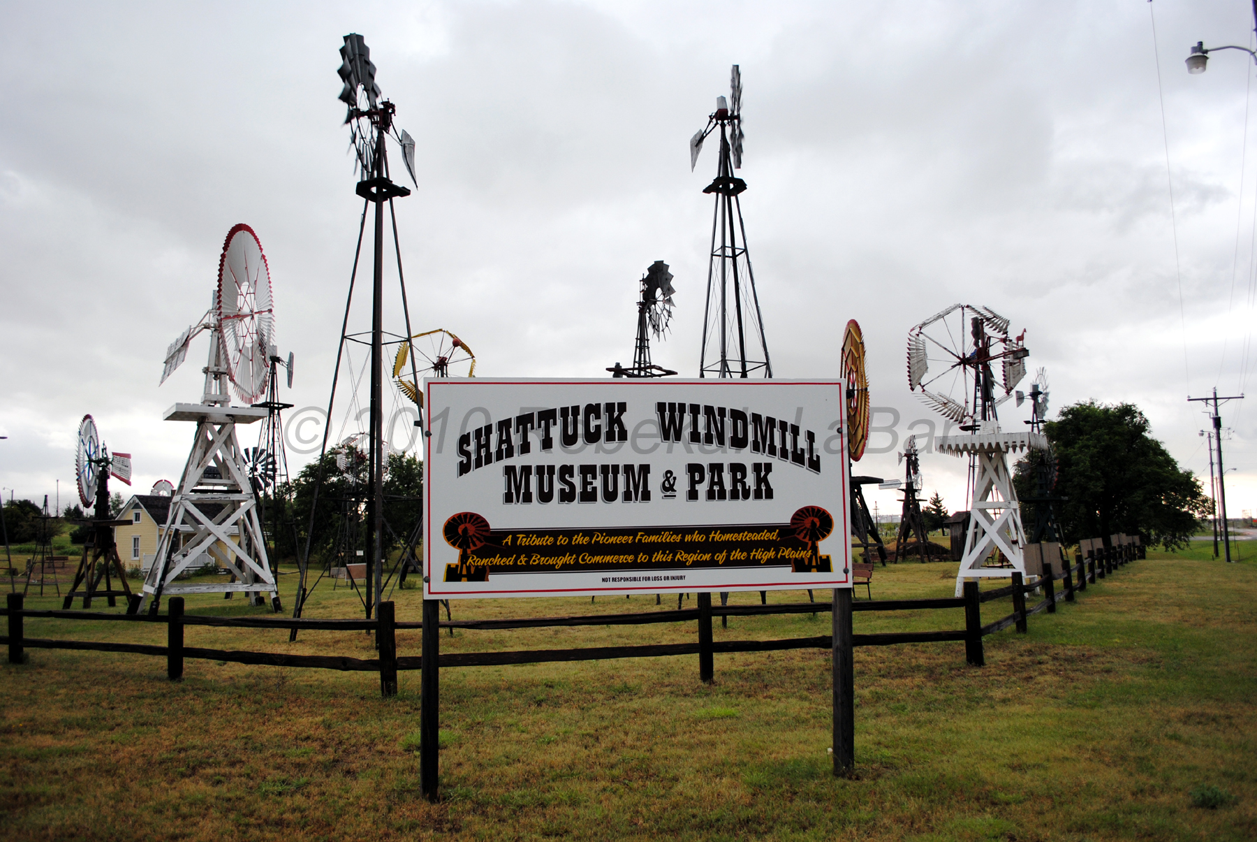
Didn’t see too much yesterday…two supercells and two wall clouds, as well as plenty of CG lightning and a very green sky (and a bit of tiny hail)…but overall it was a bit of a frustrating day as we missed a few tornadoes that were in our area. However, we did get to see a fun little windmill museum in Shattuck, Oklahoma (oh, and we also saw a flock of wild turkeys south of Lipscomb, Texas)!
However, it’s off again today; setup is fairly similar to yesterday so I won’t go into details. A few supercells with hail and tornadoes possible south of the Texas Panhandle.
Just about to head out for the area just east of Lubbock, around Matador to Ralls, Texas. Will be on Spotter Network, but not streaming (using old computer again, which doesn’t like my streaming camcorder).
From yesterday:


Permalink
« Previous Page — « Previous entries « Previous Page · Next Page » Next entries » — Next Page »
