06.13.10
Posted in Severe Weather Forecast at 10:24 am by Rebekah
I’m off to the Texas Panhandle this afternoon, as severe weather opportunities have returned to the Southern Plains for a few days.
A deep (though rather weak) trough has dug in to the Four Corners’ region, though the strongest upper-level winds are on the east side of the trough, meaning it is about to start lifting out north as it reaches the Plains. A surface low has formed along the southern New Mexico / Texas border, with an associated stationary front (later becoming warm front) lifting up through central Kansas into Iowa.
A dryline will begin to tighten this afternoon in the central Texas Panhandle, with dewpoints in the upper 60s to lower 70s and surface winds from the south/southeast in the warm sector.
CAPE of between 1500 and 2000 J/kg will be possible over the central to east Texas Panhandle (over 3000 in southeast Kansas and northeast Oklahoma). 0 to 1 km storm-relative helicity values should reach 100 to 200 or greater in the north central Texas Panhandle (0 to 3 km values forecast to reach 300). Surface to 500mb bulk shear vector forecast to be between 40 and 50 knots over the north Texas Panhandle, but barely reaching 30 knots over the south and east Texas Panhandle.
Although the bulk of storms is likely to form over the Kansas/Oklahoma border along the front, the greater chance for strong to severe storms is along the dryline, near the triple point. A line of storms is likely to form from the central Texas Panhandle up into Kansas by the evening, but I expect some of the storms along the southern end of the line will be supercells that will have the potential for large hail and possibly a tornado or two.
Initial Target: Shamrock/Pampa/Clarendon, Texas
Permalink
06.06.10
Posted in General News at 8:46 pm by Rebekah
I apologize for the lack up updates on both my website and blog for the last couple of weeks…some friends of mine from Australia and England came over to do some chasing recently, and I spent a week running around the Plains with them, having an amazing time.
I didn’t have much computer access while I was gone, so I’m only just now starting to edit photos, edit videos, and compile chase logs. This will probably take me some time, as I’m also working on a few other projects and am starting my PhD research.
Here’s a summary of what’s coming, hopefully complete within the next 2 to 3 weeks:
*May 19 chase log/photos – supercells in central Oklahoma (chase log is up, but I didn’t get around to photos yet)
*May 29 chase log/photos – multicells in southwest Nebraska
*May 30 chase log/photos – supercells/squall line in south central Kansas into north central Oklahoma
*May 31 chase log/photos/video – tornado in southeast Colorado
*June 1 chase log/photos – supercell/squall line in south central/southeast Nebraska
I am also still plodding along on Dreamweaver; one of the improved features of my new website will be the ability to hopefully scroll through large versions of chase photos, rather than having to click on thumbnails to go to individual photos, then go back to look at another one.
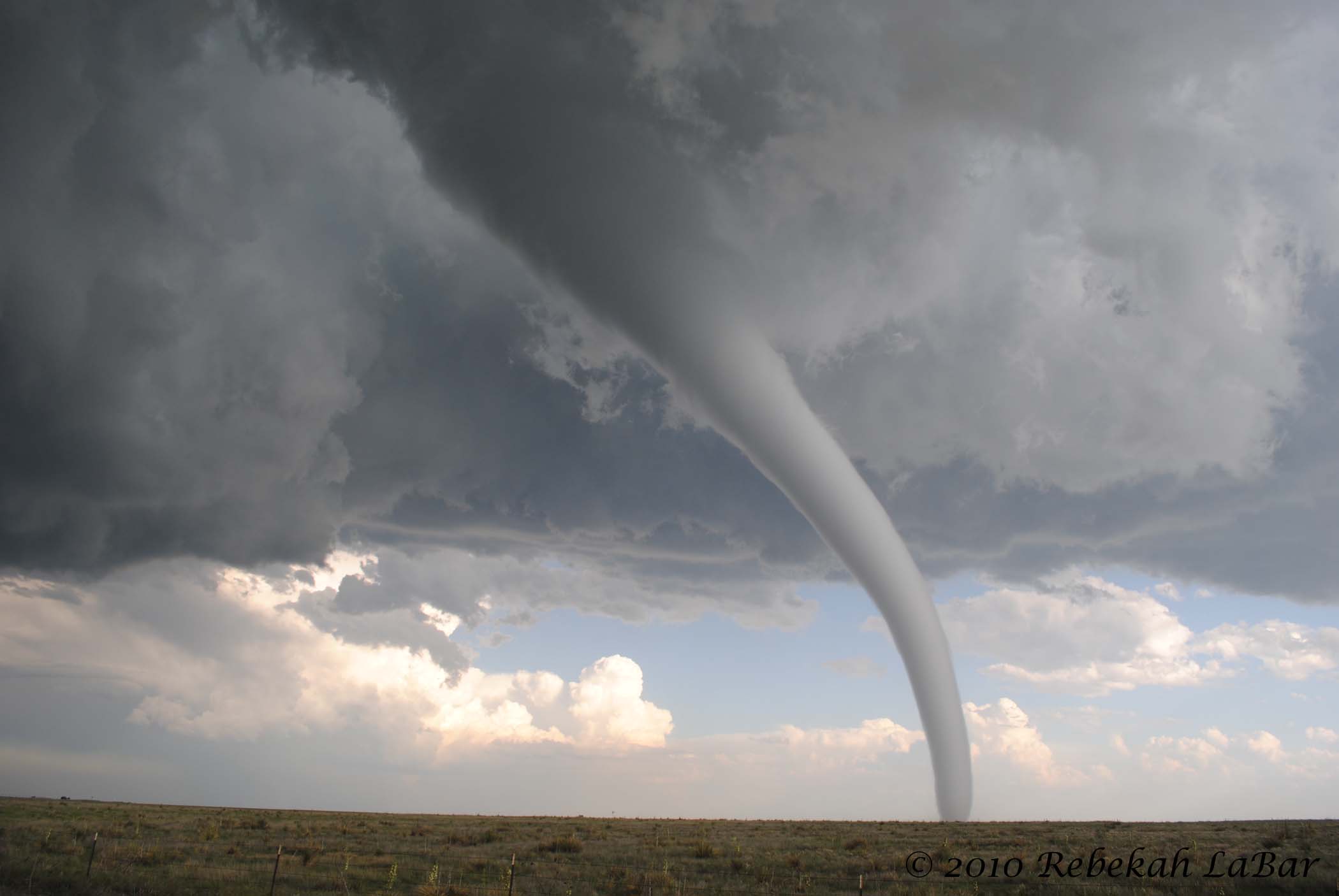
I posted a new photo of the week on my website this evening, but I’ll post again here, as it’s one of my favorites–this is of the EF2 tornado near Campo, Colorado. This will be included in the chase photos of May 31, once I get those up…

Permalink
06.01.10
Posted in Uncategorized at 4:09 am by Rebekah
Wondering why no updates lately? I’ve been chasing the Plains with some friends this weekend, and today I saw the tornado of my life (chase brief here). The following photo is only one of many photos; some of the others may be even better (I can’t pick my favorite!) and I will be posting them later in this week or next…will be chasing northeast Kansas / southeast Nebraska tomorrow, then home on Wednesday.
See below.
Enough said.

Permalink
05.23.10
Posted in Uncategorized at 7:38 pm by Rebekah
Photos and a full chase log from May 18 are up on the website; however, you may want to wait to access the photo page…
Unfortunately, as soon as I copied over the photos and updated chasing pages, I lost access to my ftp site and I can’t seem to get it back right now. This has prevented me from copying over the updated home page and full page for displaying the May 18 photo thumbnails. It’s rather frustrating, but it would appear that I will just have to wait and hope I am able to access it again soon. You can still go to the website, click on the storm chasing tab, and go to the May 18 photo page…it just looks funny right now as the thumbnails are not showing up and the background is white.
Hmph.
If you wait to look at the page until tomorrow, hopefully I will have been able to copy over the full photo page to make it look nice. If not, you’ll know why.
Photos and a chase log from May 19 should be up sometime early this week.
On a related note, when reviewing photos to post this afternoon, I compared the NWS Amarillo tornado reports and survey info from Tuesday with the timestamps on my photos. I found that one of the tornadoes occurred as I took a few photos after the mesocyclone left Dumas.
According to the NWS, there was a 200-yard tornado 2 miles east of Dumas from 6:42 to 6:45 pm. I was several miles south of the storm, looking north to the area just east of Dumas, when I saw one of many bowl-shaped lowerings. I was too far away to tell if it was a tornado or not, but I snapped some photos. One of the photos, taken at 6:43 pm, shows a cone tornado on the ground! I had to enhance the contrast in the photo by quite a bit, but hey, sometimes that’s what you need to know for sure…
As the time, location, and description matches, and the funnel cloud in my enhanced photo was indeed touching the apparent ground, it’s pretty safe to say that Jeff and I actually saw TWO tornadoes on Tuesday–albeit both low-contrast, mostly rain-wrapped tornadoes.
This is a bit of a milestone for me, since if all the tornadoes I think I’ve seen were indeed tornadoes (a few may not have been, granted, but I’m pretty convinced they all were), I’ve now seen 20 tornadoes.
On a related note, Wednesday, May 19th, was my 40th chase (my first tornado was not seen on a chase, though…it went right past my house…).
Not that it matters much, however, especially as I don’t really measure the success of my storm chases on whether or not there were tornadoes. I’d still MUCH rather see amazing storm structure or large hail (not falling on my car, mind you!) than low-contrast, rain-wrapped tornadoes. Just the same, if a supercell I’m on is actually producing tornadoes, I’d prefer to see at least one. 😉 In the case of Wednesday, though, if I’d seen one of the southern tornadoes, I probably would have missed out on one of the most amazing sunsets (pics coming soon)…
But I digress.
Note: contrast is still not very good on the following image (you may click to enlarge), and the enhanced contrast means a more pixelated image, so you may need to squint and tilt your head a bit to see the cloud reaching the ground. 😉

Permalink
05.22.10
Posted in Weather News at 3:31 pm by Rebekah
Just over a month ago, I posted on the unusual lack of tornadoes through mid-April. As expected, however, shortly after that post, there was an explosion in this year’s tornado count.
Here’s how we stand through Thursday, May 20 (does not include the 5 tornado reports from yesterday).

This graph (click to enlarge) from the Storm Prediction Center shows the trend in local storm reports (LSRs) of tornadoes in the U.S. LSR values may be slightly higher than the actual tornado count, as some tornadoes may have been reported more than once.
The next graph, also from the Storm Prediction Center, shows annual tornado trends and percentiles; calculation details are at the website at the bottom of the figure. The red line is the maximum tornado count in a single year and the pink line is the minimum tornado count in a single year. The other lines show tornado trends in quartiles.

Note that after briefly dropping below the all-time minimum, this year’s tornado count quickly jumped up in late April, and we’re now approaching the 25th percentile.
Although it looks like we’ll be getting a big ridge over the central US this coming week, inhibiting widespread severe storms for at least the next couple of weeks (though there are still likely to be localized areas with severe weather), the storm season is not over yet. There is usually a ridge that comes for a week or two in May, before another peak in tornado season comes in early or mid-June across the Central to Northern Plains.
Permalink
« Previous Page — « Previous entries « Previous Page · Next Page » Next entries » — Next Page »