05.10.10
Posted in Severe Weather Forecast at 9:22 am by Rebekah

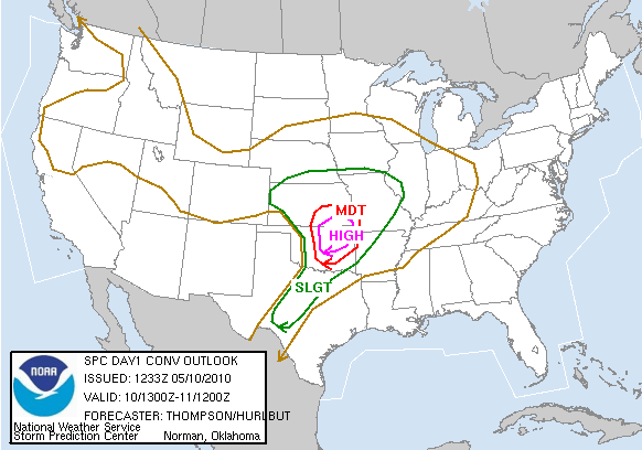
SPC Day 1 Convective Outlook
Hmm…where to start. The first High Risk on the Southern Plains since April 26th of last year, and the third High Risk in less than two weeks. The SPC has the tornado risk at 30% hatched, meaning there’s the potential for EF2 or greater tornadoes within 25 miles of a point.
A shortwave trough is fast approaching and is expected to be over central Kansas / northern Oklahoma by evening. A surface low will move across southern Kansas today, as a warm front lifts through Oklahoma up into central Kansas. A dryline will tighten over west central Oklahoma by late afternoon/evening (NAM dryline keeps pushing back west…something to keep an eye on…), when a narrow band of 70F dewpoints is forecast to stretch north through central up into northeastern Oklahoma.
CAPE of 3000 to 4000 J/kg is expected along the dryline, from northeastern Oklahoma southward all the way to San Antonio. Mid-level lapse rates will be very steep in this region, approaching dry adiabatic.
With south-southeasterly surface winds in central into eastern Oklahoma and southeastern Kansas (the NAM shows better backed southeasterly winds in north central/northeastern Oklahoma and southeastern Kansas, ahead of a dryline a bit farther west of the GFS), and west-southwesterly winds at 500mb, shear profiles will be more than sufficient for rotating storms. The NAM shows 0-1 km storm-relative helicity values of over 100 in most of Oklahoma (ahead of the dryline), with over 400 in northeastern Oklahoma into eastern Kansas and Missouri (0-3 km SRH is over 300 in Oklahoma and over 500 in northeastern Oklahoma into eastern Kansas and Missouri). Soundings and especially hodographs appear to be textbook for classic supercells in much of Oklahoma (from I-35 east) and southeastern Kansas.
Everything appears to be coming together for a major severe weather outbreak from central into northeastern Oklahoma and southeastern Kansas (although severe storms are certainly possible all the way south along the dryline into west central Texas). Without much of a cap (GFS shows a stronger cap, but it shouldn’t be much of a problem–if anything, it could help stronger, more isolated storms to form), it looks as if there will be supercells with large hail and strong tornadoes from central Oklahoma into southeastern Kansas (and possibly southwestern Missouri near/after dark).
A few early showers in northeastern Oklahoma and south central to southeastern Kansas could set up a few outflow boundaries to assist in storm development later in the day.
Storm motion could be a problem as far as chasing goes, today, as the storms will be moving fast (near 40 mph) through an area with some trees and not the best road network.
Nevertheless, I will be out there streaming today (see my tracking page on my web site), somewhere in north central to northeast Oklahoma. VORTEX2 is already up in the area, hoping to finally record some quality data, hopefully in rural areas.
My target area for the last couple of days has been Ponca City, Oklahoma to Arkansas City, Kansas. If the NAM comes closer to verifying on the dryline than the GFS, storms may form farther west in north central Oklahoma / south central Kansas…however, as storm motions will be pretty fast, it would be better to stay ahead of where I think the storms will form, so I don’t have to play catch-up as much.
I think for now, I will target Blackwell, Oklahoma. I’ll discuss with my chase partners, Jeff and Esther, within the next hour, to see what they think, and then we’ll probably head out around 10:30 to 11 AM…
Permalink
04.24.10
Posted in Uncategorized at 10:48 am by Rebekah
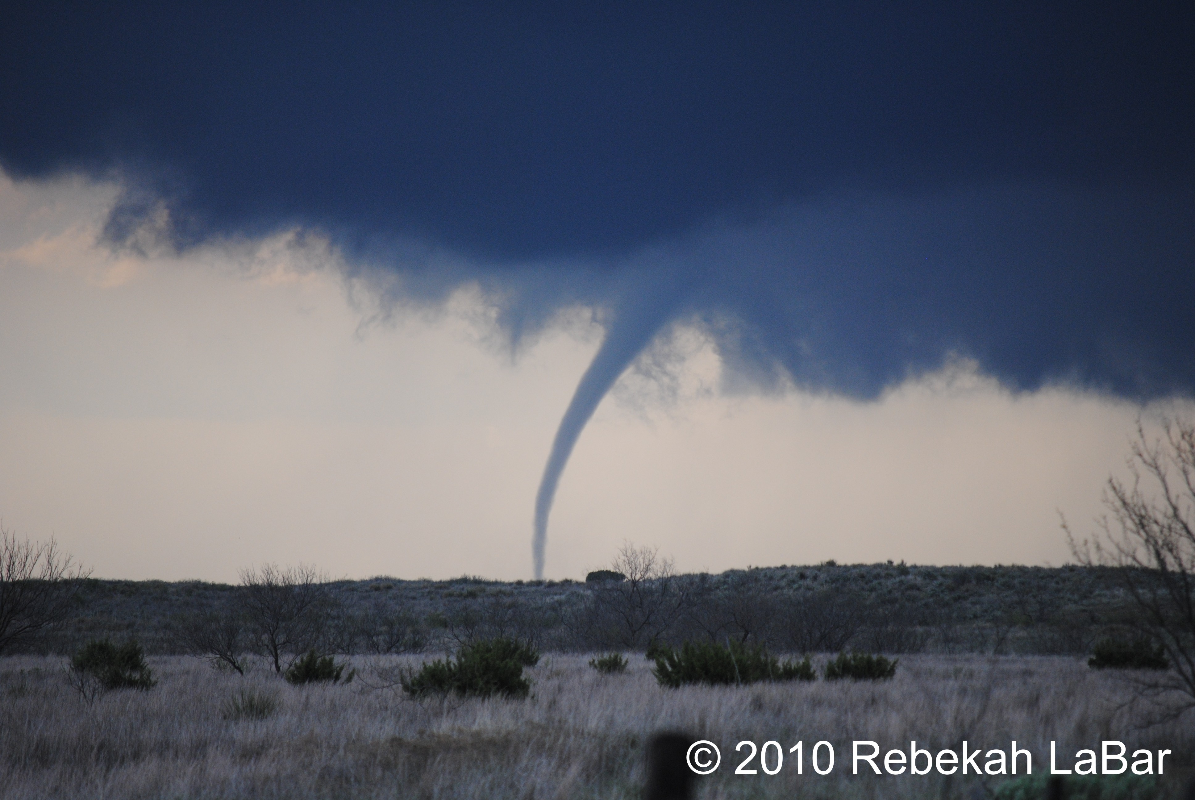
The Texas target verified on Thursday, and I saw my first tornado of the year! It occurred out in the middle of nowhere, and according to the NWS it only damaged some power poles. It was the strongest, most long-lived tornado in the panhandle that day (not including the wedge near Childress around sunset), rated at EF1 and lasting 20 minutes.
I will write up a full chase log and post photos and video on my website hopefully later this weekend (probably Sunday evening or Monday), but here’s a teaser:

EF1 tornado on 22 April 2010, near Goodnight, Texas (click to enlarge).
Now I’m off to Catoosa (just northeast of Tulsa) to attend a memorial event for the seven victims of the 24 April 1993 F4 tornado, the strongest tornado to ever hit the Tulsa area. A 35-foot-tall metal tornado statue will be unveiled, and a large electric motor will cause it to rotate. I’ll post pictures later today or tomorrow.
Permalink
04.22.10
Posted in Severe Weather Forecast at 11:02 am by Rebekah
Today there’s a surface low setting up over Colorado, with a warm front that will later extend through central Kansas and a cold front that will move into eastern New Mexico. A dryline will set up in the central Texas Panhandle, with dewpoints ahead of the dryline in the upper 50s and lower 60s. Winds will back south of the warm front and along the dryline, where CAPE is forecast to reach between 1500 and 2000 J/kg. A large trough with a closed low is moving over the southwest, and will provide the lift and upper-air winds to support strong to severe storms. Wind shear will be present, especially near the warm front.
I expect there will be supercells today along the dryline in the Texas Panhandle, with some large hail and possibly a few tornadoes. Another point of concern is the triple point, up near the low…it’s a bit of a tough decision for me, between messier precipitation and possibly better shear up north in Kansas, and isolated supercells (at least until the cold front catches up to the dryline and we get a squall line, hopefully not ’til after dark) and slightly lower shear along the dryline. At this time I’m favoring the dryline, partly because it’s the Panhandle–and I really can’t resist a dryline chase in the Panhandle of Texas! Besides, cloud cover may prove too formidable up near the low.
I may be streaming today on ChaserTV, if I get my camcorder to work with my old laptop (newer one still in the shop). I will probably be on Spotter Network as well.
Target: Childress, Texas, to possibly Clarendon/Silverton
Time of Departure: now!
Permalink
04.14.10
Posted in Weather News at 9:38 pm by Rebekah
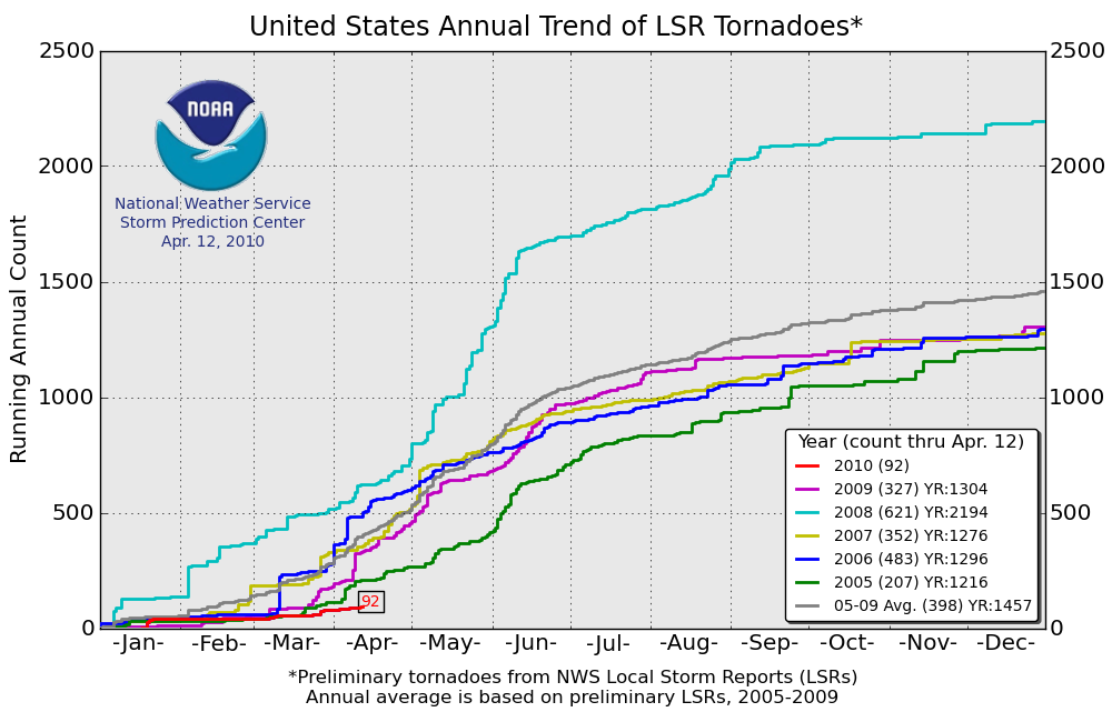
Mid-April in Tornado Alley. Only 93 tornado reports so far.
Over the last 30 years, there were on average 191 tornadoes between January 1 and April 15.
Over the last 10 years, there were on average 237 tornadoes.
Over the last 5 years, there were on average 338 tornadoes.
Tornado reports have, on average, gone up over recent years, but that is due in large part to increased tornado awareness, increased storm chasers and spotters, and increased tornado detection through Doppler radar.
But that’s not the point.
The point is that this year is below average. Take a look at the plot below, from the Storm Prediction Center. This graph shows the trend in local storm reports (LSR) of tornadoes in the U.S. Values may be a little higher than the actual tornado count (some tornadoes may have been reported more than once). The last five years are shown, as well as the current year up through April 12.

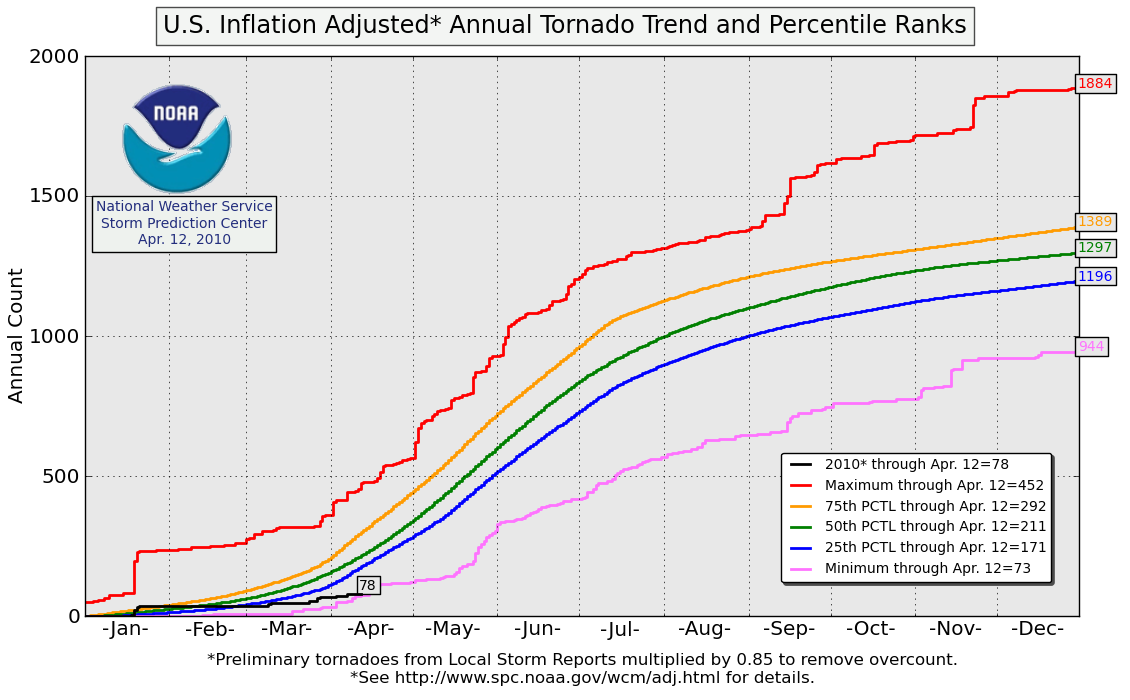
Now look at the graph below (click to enlarge), also from the Storm Prediction Center. This plot shows annual tornado trends; if you’re curious as to how exactly the trends were calculated, see the website on the bottom of the figure. Basically, the red line is the maximum tornado count in a single year and the pink line is the minimum tornado count in a single year. The other lines show tornado trends in quartiles. Currently, 2010 is in the all-time lowest 25th percentile, near the minimum. That’s how slow this year is in terms of storms and tornadoes.

One thing to note, however, is that in 2004, there was an all-time record of over 1800 tornadoes in the U.S. From January 1 to April 15 of 2004, only 91 tornadoes were reported. As of today, April 14, 2010, 93 tornadoes have been reported this year.
Currently the weather pattern over much of the U.S. is more summer-like than spring-like, with few good troughs digging into the central or southern Plains…however, all this just goes to show that storm chasers shouldn’t be too worried about this season yet (and sane citizens of the Plains shouldn’t get too excited yet)…
Permalink
04.06.10
Posted in Uncategorized at 12:12 pm by Rebekah
Supercells are possible today in eastern Kansas and northern Oklahoma…the trough will be moving over Colorado/New Mexico today, and dewpoints along the dryline in central Oklahoma are forecast to be in the mid 60s through 00Z (7pm). CAPE values of 1500 to 2000 are forecast in a narrow region along the dryline, and storm-relative helicity may be above 200 in central Oklahoma. Models show precipitation breaking out by 5pm in eastern Kansas and northern Oklahoma…if storms remain discrete, large hail and a few tornadoes are possible.
Target area: Ponca City, Oklahoma towards possibly Bartlesville Oklahoma and northward into Kansas
Will be leaving around 2pm…
You can track me at Spotter Network once I am on the road.
Permalink
« Previous Page — « Previous entries « Previous Page · Next Page » Next entries » — Next Page »
