04.06.10
Posted in Uncategorized at 1:30 am by Rebekah
Today was a bust of sorts for northwest Oklahoma/southern Kansas along the dryline.
I say “of sorts”, because it was rather expected: all parameters practically screaming supercells except for the lack of forcing. So really, the forecast was nailed. Some of us still wanted to be there to see it for ourselves, though–especially in case the forecast did fail. Surprise, surprise, the cap remained in place.
To make a long, rather uninteresting day short, Jeff and I drove up to Enid, briefly stopped to figure out what we were doing, and continued on to Alva. We wound up sitting at the dryline for nearly 3 hours just south of Alva, watching some itty bitty cumulus clouds form and then quickly dissipate.
Total chase miles yesterday/today: 390 miles
Total chase hours yesterday/today: 11 hours
On the up side, I tested all of my equipment, and with the exception of the new tracker page I put up on my webpage, everything works (the tracker page was not showing my position, but the actual Spotter Network site was). Tracking worked well, streaming live video worked well (it was very exciting; I streamed some cows and a few flat cumulus clouds), and I found out that I won’t even come close to filling up on my cell phone tethering data plan. Even the cell phone data coverage in non-3G areas was still fairly fast. The biggest problem I foresee would be the video cable coming unplugged from the computer, if there’s too much excitement and potentially moving stuff around in the middle of a storm. It was nice to test in a low stress, low expectations day.
In short, I had a great day, despite the blue skies!
I’ll post a full chase log (it’ll be short!) with photos (they’re rather boring!) on my website probably on Wednesday.
Tuesday looks it will be better than today, with many of the parameters still being there, but stronger forcing. Multiple supercells forming along the dryline moving into central Oklahoma could be the scene of the day. Potential target could be southwest into west central Oklahoma, but I have not looked at the setup in too much detail yet (will do so in the morning, and evaluate).
Permalink
04.05.10
Posted in Uncategorized at 12:25 pm by Rebekah
To chase or not to chase…that is the question.
With much hemming and hawing, I have decided to chase. If nothing else, it’s a chance to test some new equipment before a very good day.
Today’s setup: large trough to the west, surface low in western Kansas, with a warm front extending into Iowa and a dryline from central Kansas into northwest Oklahoma and the east Texas Panhandle. Dewpoints are in the 60s in much of Oklahoma and central/eastern Kansas, providing ample moisture. Instability is good, with forecast CAPE values of 2000 J/kg or more. Wind shear is great, with evening helicity values forecast to be 100 to 200 over much of Oklahoma and Kansas. The better target today looks like Iowa/Missouri along the warm front, but that is outside of my chase region so I am not looking at that too much.
Everything looks superb today for beautiful supercells with large hail and tornadoes–except for one thing, which is why I had so much trouble deciding whether or not to go out today. There is a cap over much of Oklahoma and Kansas, which will prevent much rising motion. IF, and that’s a big if, we can get some sort of shortwave trough or moisture convergence or good lift, then an amazing, isolated supercell or two is very likely. However, this is a highly conditional forecast, and today could wind up being a big blue sky bust for my target area. There is a narrow area right in front of the dryline that may be ok, but I am prepared for this day to be a bust. I would rather be there and bust, though, than not be there and miss an amazing supercell or two.
Hopefully storms will start initiating by 5 to 6pm, and if they produce anything, it may be just before or around sunset.
Target area: Alva, Oklahoma to Medicine Lodge, Kansas
Once I’m on the road, you can now see where I am (provided that I have cell coverage) on Spotter Network. If I happen to see a storm, if I am streaming live that will be on ChaserTV.
Permalink
04.01.10
Posted in Severe Weather Forecast, Weather News at 3:08 pm by Rebekah
Here we go!
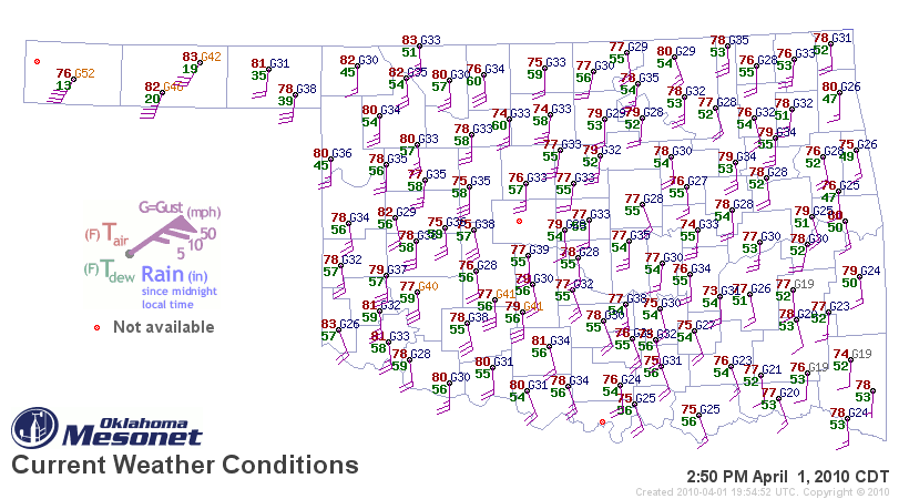
Oklahoma dewpoints are finally in the mid-50s; some dewpoints in western Oklahoma are already up to 60 today, ahead of a dryline. Note the surface map below (click to enlarge), as of 2:50pm, from the Oklahoma Mesonet.
As the legend shows, dewpoint is the number in green. The higher the dewpoint, the more moisture there is in the air. For thunderstorms, especially severe thunderstorms, chasers often look at 60 °F as the magic number.
Note that in the panhandle, dewpoints are in the teens — this is because there is a dryline in the panhandle, or a line where dewpoints are low on one side (with winds usually from the west) and high on the other side (with winds usually from the south or southeast). Temperature is given in the red numbers, while the staffs/barbs at each station indicate wind direction (mostly from the south in this case) and speed (based on number of barbs on the staff).

There is a slight risk of severe thunderstorms today in western Oklahoma, but the cap (temperature inversion that acts as a “lid” to rising air) is so strong it is unlikely that much of anything will break through it.
Tomorrow there is also a risk of severe weather, but primarily east of here. The next time I go chasing may be early next week, as it looks like we will not only have a decent trough, but also finally have the moisture and instability we’ve so desperately needed. The actual day and location is still rather up in the air, but as the models start to resolve the details of the setup, I will begin to have a better idea.
Stay tuned…
Permalink
03.28.10
Posted in Weather News at 3:14 pm by Rebekah
Warm, south winds and mostly sunny skies? Temperatures in the 70s and 80s? What is this strange weather?
It appears as if spring has finally arrived.
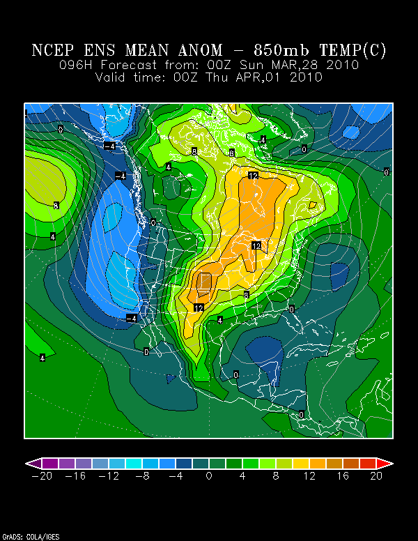
Take a look at the map below, from the NOAA Earth System Research Laboratory. This is a model forecast of 850mb (low-level atmosphere) temperature anomalies for 00Z on Thursday, or 7pm Central Time on Wednesday. Wednesday is probably going to be the warmest day of the week for central Oklahoma (unfortunately, for those of you on the West Coast, you will be receiving some cooler weather). Note that the 850mb temperatures in central Oklahoma are forecast to be 8-10 degrees CELSIUS above normal!

Why are we expecting such warm weather?
The models are finally showing a nice ridge of high pressure beginning to build over the eastern US early this week, with a trough of low pressure over the western US (the thin gray lines on the plot above). This pattern is great news if you want southerly surface winds advecting warm, moist air up into the Southern Plains.
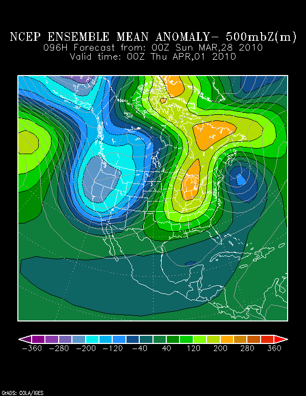
The map below, also from the Earth System Research Lab, is a model forecast of 500mb (mid-level atmosphere) height anomalies for the same time as above (7pm Central Time on Wednesday). What you should take from this map is that there is higher-than-normal pressure (higher heights; i.e., the ridge)) in the eastern US and lower-than-normal pressure (lower heights; i.e., the trough) in the western US.

A potentially good piece of news for storm chasers is that the southerly winds can give us the warm temperatures and higher dewpoints that we need for strong thunderstorms to form. Moreover, the trough in the West looks like it may be sending a number of shortwave troughs our way, starting late this week. Those troughs provide the needed lift for a thunderstorm. As I’ve mentioned before, we’ve had plenty of lift and wind shear for strong thunderstorms, but an overall lack of moisture and instability–at least until next week, shortly after Easter.
Time to gear up for the storm season and batten down the hatches–it looks as if April could be a busy month.
Permalink
03.25.10
Posted in Weather Myths at 2:21 pm by Rebekah

Have you ever heard that when the sky turns green, it means a tornado is coming?
This saying is an oft perpetuated myth, especially in the central US. Truth be told, no one knows for sure what causes a green sky to form. Somehow it’s not a high priority in science right now. 🙂 One thing we do know, though…green skies are often observed with severe thunderstorms, but the sight of a green sky by no means indicates that a tornado is about to form or large hail is about to fall.
Although we are not sure what the exact mechanism is behind the green sky (there are multiple theories you can find on the Internet; some have more credibility than others), the color is likely a result of the liquid water and hail in some strong thunderstorms. Water absorbs and re-emits longwave radiation very well. In fact, water vapor contributes to the greenhouse effect more than any other gas in the atmosphere. One theory is that when sunlight reaches the water droplets and ice within a thunderstorm, the red light is absorbed somewhat, while the green light is reflected back to our eyes. The heavier the precipitation, perhaps the greater the color green.
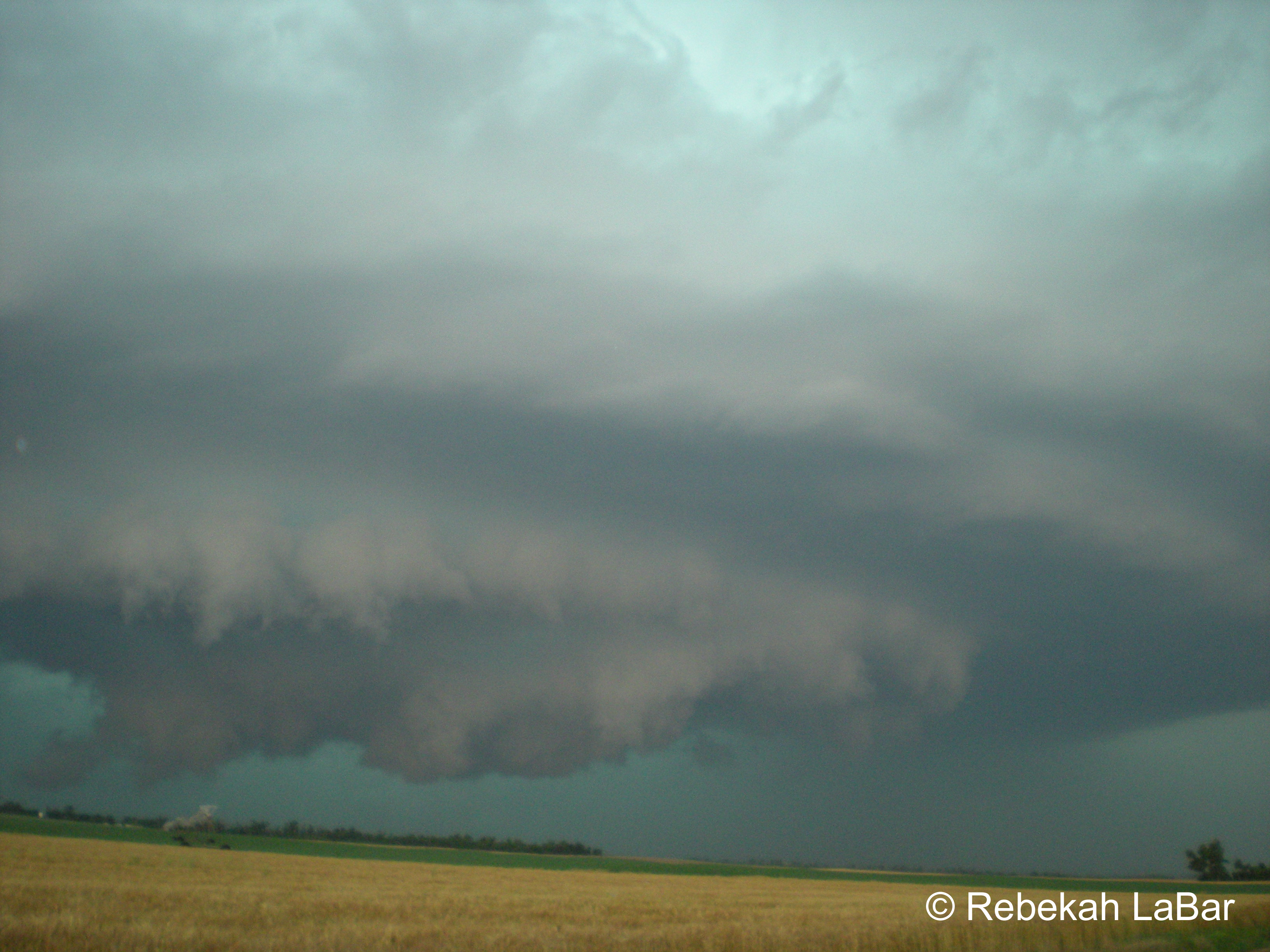
I chose the name “Green Sky Chaser” for my website and blog because I love the color green. My favorite color of all is a combination of green, blue, and gray: the practically indescribable, pale turquoise color of a stormy sea, and best of all the awe-inspiring color of the sky during some amazing severe storms. I have witnessed several brilliant, blue-green skies while storm chasing (see photo, above; for more photos from my storm chasing adventures, see my website). To me, a green sky means ominous, breath-taking beauty. Tornadoes are not my sole purpose for chasing; the sight of a tornado may be the icing on the cake, but I’d travel many miles just to see lightning, hail, amazing storm structure, and an awesome green sky.
Permalink
« Previous Page — « Previous entries « Previous Page · Next Page » Next entries » — Next Page »
