03.24.10
Posted in Weather News at 4:36 pm by Rebekah

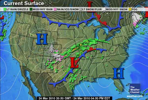
While Denver digs out from nearly two feet of snow in places and attempts to restore power to thousands of homes and businesses, central Texas is experiencing some strong thunderstorms. There is currently a severe thunderstorm watch box out for north central and central Texas, but instability and vertical, directional wind shear is not great enough for very severe thunderstorms. The thunderstorms are currently forming along a cold front (see map, above).
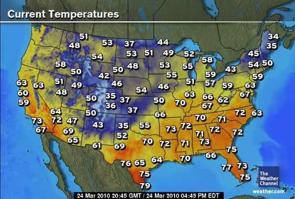
Most of the cooler air in the US (see below) is currently confined to the Colorado Rockies (as well as Maine; they are under a snowstorm as well right now).

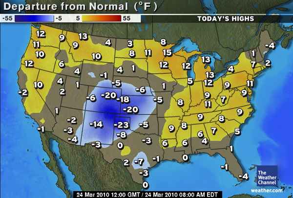
To see how today’s forecast highs (by The Weather Channel) stack up against the normal (or average) highs for today, see the map below. You can see that Colorado, Kansas, New Mexico, and the Texas Panhandle are well below average, while much of the rest of the US is (finally) near or above average. Yay.

The big question remains, when will there be some good, chase-able severe thunderstorms within my region again? There are a few interesting-looking troughs that may move through in the first week of April, but it appears that a lack of moisture and instability may still be a big problem. Obviously the models can and will change before then, but the first decent chance of a big severe weather day may not be until mid-April or so. In the meantime, that gives me more time to get work done and write blog posts about nothing much in particular. 😉
Permalink
03.12.10
Posted in Uncategorized at 6:01 pm by Rebekah
As storm chasing season begins again, I thought I’d share a few storm chasing tips, including what I wish I knew before I went on my first storm chase. 🙂
- Don’t forget to bring food. The most common time for tornadoes to form is in the late afternoon and early evening, and tornadoes don’t wait for you to make a run to Taco Bell. I often find that when I’m in hot pursuit of a tornadic supercell, I don’t start to get hungry until well after my normal meal time; however, it’s nice to have at least a healthy (or sometimes not so healthy?) snack on hand for when you do get hungry.
- Hydroplaning is the number one danger while storm chasing. Tornadoes? Dangerous if you’re in their path, but not too bad as long as you don’t get too close, stay away from flying debris, keep them in sight, and know where they’re going. Lightning? Not a big deal if you stay in your car, but still dangerous. Heavy rain? Now THAT’s scary! Rain makes it very easy for drivers to hydroplane. On my second storm chase, a fellow chaser rear-ended the car I was riding in. Slow down and watch where you’re going.
- Be patient. Storm chasing is not all action. In fact, sometimes there is much more sitting around and waiting for storms to form in your target area than actual driving.
- You won’t see a tornado every time. This goes along with #3; even in the Plains, the chances of a tornado hitting any one place are pretty small. Even if you’re a good forecaster and an experienced chaser, sometimes you will have bust days with no storms and sometimes you will have bust days where there are tornadoes just a few miles from you.
- Take maps, even if you have a GPS. Sometimes, technology fails. Actually, lots of times, technology fails. Even if you have a great GPS that has never failed you and very likely never will fail you, you don’t want to be in a sticky situation when something happens to it. Always take paper maps, either as your primary or secondary source. Oh yes, and always have an escape route handy–few things in life are scarier than being sandwiched between a tornado and a large hail core, and not having a way out.
- Chase with a full tank of gas. This kind of goes along with #1. It’s frustrating and dangerous to be chasing a tornado when you’re in the middle of nowhere Kansas and low on gas.
- Don’t pull off the road unless there is a shoulder or very dry dirt. That should go without saying. In the heat of the moment, though, it’s easy to forget. I once needed to make a quick stop to adjust some equipment, so I pulled off the road onto a dirt/grassy area. Did I mention it was Oklahoma, where there is a lot of red clay? Oh, and did I mention that it had just rained, so the ground was soft? My car sank in about 8 inches of mud.
- Occasionally you may see a tornado. In contrast to #4, if you chase often enough, and learn to forecast well enough (or chase with others who know how), eventually you will very likely see a tornado. Wait a minute, isn’t that the whole point? Chasing is so hard, sometimes I hardly even believe I will ever see another tornado–even on a good day! I am actually surprised at how I am surprised whenever I see a tornado. I have seen about 15 tornadoes over the course of my short time chasing, and I have to tell you I am shocked and amazed whenever I see one. It’s an incredible feeling when you first spot that rotating column of air.

- Hail sales really do exist. I heard about these before I moved to Oklahoma, but I used to think they were just a joke. Cars get damaged by large hail in the Plains; it’s a fact of life, chasing or no chasing. When this happens in a car dealership, the dealerships often have a “hail sale”, where you can buy a new car pretty cheap–as long as you can live with some dents and perhaps a broken window. Hail is cool to see, but not fun to mess with–unless you enjoy having your car smashed, stay away from falling golf balls and baseballs.
- Don’t record video in a car without a dash mount or tripod. I have never got car sick in a car, even when reading. I do, however, get very nauseous when I watch chase videos that were recorded by someone holding a camcorder up to a moving car window, while traveling at 70 mph. By the way, this includes some of my own chase videos. Get a dash mount or tripod or something if you plan to film out of a moving car (or a really good camcorder that does well under these conditions). I recently bought a no-slip dashboard cushion for a GPS–only I’m going to use it for my camcorder instead. I already tested it, and it works great–I just place the camcorder in the flat part of the cushion, which I place on the dashboard, and the camcorder won’t even move when I go around corners.
- Chasing isn’t all fun and games. Finally, people’s lives are being affected by the storms we chase. I never realized this more than when I saw Greensburg being destroyed by a 1.7-mile-wide tornado a few years ago. At the end of the day, no matter what your reasons for chasing, and no matter how much you enjoy getting that thrill ride and those money shots–remember to stop and think about that building you saw fall apart, and even the corn field that you saw get ripped up. Yes, even though we root for tornadoes to go through open fields, a tornado could still be damaging someone’s crop and income for the year. Think about this before you start cheering on that tornado.
Permalink
03.09.10
Posted in Uncategorized at 6:31 pm by Rebekah
Well…you win some, you lose some.
I set out from Norman at about 2pm with a fellow grad student. Based on the dismal outlook for the day, I was expecting to only see a few storms behind the main squall line, with perhaps some lightning and hail. And maybe a supercell.
Two squall lines formed early in the day; one was well ahead of the dryline and came through central Oklahoma during the late morning. The second squall line formed just along and ahead of the dryline, and was in western Oklahoma at about the time we left. We drove southwest on I-44, as the best wind shear, instability, and moisture appeared to be in southwest Oklahoma. An area of decent instability was in northwestern Oklahoma, near a surface low, but I didn’t feel quite as confident about that region. The clouds looked like they would clear out of southwest Oklahoma before northwest Oklahoma, providing the chance for more heating and instability in the southern region. This was a very tough decision, I might add.
By the time we got to Lawton, the clouds were clearing above us and we could see some cumulus clouds forming to our west. We drove west on Highway 62 to Altus. Along the way, we saw a cumulus congestus cloud grow into a low-topped thunderstorm with a nice anvil to our northwest. I told Jeff that that would probably be the storm of the day, but it didn’t look terrific, and we were hoping that more storms would form to the south and come up our way.
When we got to Altus, the storm was the strongest on radar, but it was about to cross I-40 and we likely wouldn’t have been able to catch up with it unless we made an immediate decision to go north and not waste any time. I have been burned in the past, however, by making a sudden decision to leave the best-looking area to go after a semi-bad-looking storm, only to have my initial target area produce the best storms. So after some deliberation, we decided to meander over to Braum’s for some chocolate milk shakes, and then go north on Highway 283.
I heard of some 1-inch hail reports on the large storm, but comforted myself with the fact that we likely would have other storms forming nearby, and we could actually play around with a smaller storm just to the south of the big one. North of the small town of Willow, I stopped for several minutes so that Jeff and I could get some photos. The sun was low in the sky, moving behind a cloud in the middle of the flatlands of western Oklahoma. To our north and east, we saw dark clouds and rain. We even saw an occasional lightning strike! It was quite a peaceful sight.
As we got back in the car, I decided to go due north on Highway 34 instead of continuing northwest on 283. I still hoped to catch some hail and more frequent lightning. However, much to our dismay, I turned on the radio and found out that the initial northern storm had already produced a tornado north of Elk City on I-40, and a second one was on the ground! Gutted, we knew we had missed the surprise show of the day, not 50 miles to our north!
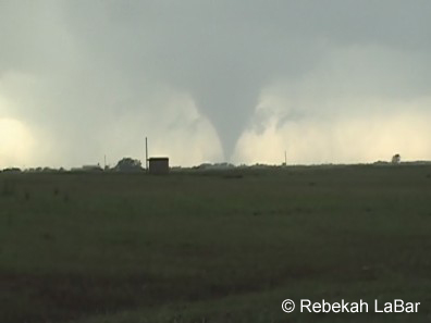
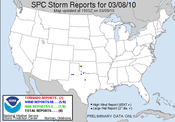
Some chasers, having picked a more northern target, saw a beautiful, multi-vortex, stovepipe tornado that was on the ground for some 40 minutes or more before a second tornado touched down. The tornadoes were rated EF2 and EF0 as they damaged some buildings in Hammon and Butler, Oklahoma, but I didn’t hear of any serious injuries.
I am not sure why more storms didn’t form to the south; the greater instability was right about where we were, in southwest Oklahoma. Shortly before the tornado was reported, Storm Prediction Center forecasters issued a Mesoscale Discussion and said they expected a tornado might form considering the stronger vorticity in the area associated with the low. By the time the tornadoes formed, the greatest wind shear was well east of us, so I suppose this was the only hope for a tornado to form. Again, we were probably too far away to catch the storm in time from Altus, but I may always wonder if we could have! I have had little success chasing near lows, but live and learn. 😛
It was still a fun, relaxing chase…up until the point where we knew there was a tornadic storm and we wouldn’t be able to catch up with it…shortly after this, we decided to head home and saw a bit more lightning and a nice rainbow. The next storm setup may not be for another couple weeks…but of course many OU students are optimistic that something may occur during our spring break next week!
See this page for chase accounts and photos of the tornado from other storm chasers. See this page for information and photos from the National Weather Service on the storms and the damage survey.
I will post some non-supercell, non-hail, non-lightning, non-tornado photos on my website perhaps later tonight or tomorrow.

Permalink
03.08.10
Posted in Severe Weather Nowcast at 1:27 pm by Rebekah
About to head out to western OK to go chasing…or more like an equipment testing session with thunderstorms. 😉 There’s already a couple of squall lines, the stronger one being along the dryline. Hoping for some lightning and perhaps small hail. More later…
Permalink
03.06.10
Posted in Severe Weather Forecast at 1:00 pm by Rebekah
Spring thunderstorms are coming back to the Plains! The first real chase setup looks like it will be on Monday (at least for the Southern Plains; yesterday there was a marginal chase setup in Nebraska/northern Kansas) . It doesn’t look great, but early season storm setups rarely do.
Models are finally showing some consensus on this one; a strong upper-level low/trough is forecast over west Texas by 00Z on the 9th (i.e., 6pm on Monday). Models show a surface low underneath the upper-level low, centered over southeast Colorado/southwest Kansas/west Oklahoma Panhandle/north Texas Panhandle. Surface winds around the cyclone will draw warm, semi-moist air from the Gulf of Mexico up into west Oklahoma. The 60F isotherm is forecast to be in either through southwest or central Oklahoma. It appears that there will be a dryline just ahead of the cold front in the east Texas Panhandle. Surface dewpoints may be in the 50s in southwest and possibly south central Oklahoma, with the 60F isodrosotherm in central Texas. Low CAPE values (a measure of instability–desired for much rising motion) of about 500 to 1000 J/kg may be realized in west Oklahoma and north central Texas. Helicity values (a measure of wind shear) are forecast to be more than decent for rotating storms; between 200 and 350 from 0-1 km in central Oklahoma/north central Texas (as well as a small portion of southwest Oklahoma), and 300 to 650 from 0-3 km in the same region.
Remember how I said the other day there are four primary conditions that severe storm forecasters look for? Monday’s setup has plenty of lift and shear, but moisture and instability are the greatest limiting factors. I am concerned that there may be too much cloud cover over Oklahoma and north Texas for enough heating to occur. I am also concerned that there may not be enough low-level moisture for good storms with low bases. At present, it looks as if there will be so much forcing that storms will break out, but they will quickly form a squall line.
However, I do think there may be some isolated storms perhaps behind the major line, along the dryline, or tail-end charlies (storms at the bottom of a line) that might have a chance of producing something interesting. Even within the line there may be some marginally severe hail.
I am keeping a close eye on this setup and am starting to consider taking a little drive southward on Monday…not so much for the sake of a good chase, but to test out my new equipment and see how coordinated I can be with my new setup on a marginal day. I figure it’s better to test new equipment on a marginal/bad day than on an excellent day and then have everything go wrong. 🙂 For now, I like the area between Wichita Falls, Gainesville, and Graham, Texas, as well as central Texas (though I wouldn’t want to go that far south unless it looked spectacular)…but that could change with the next few model runs…
Permalink
