03.26.11
Posted in Severe Weather Forecast at 8:00 am by Rebekah
I feel like I’m the only storm chaser who has only chased one day so far this year. I know that’s not true, but a number of chasers have already bagged multiple tornadoes and storms.
To be fair, there really haven’t been any good setups yet in my early season chase region. Before April (or really even May) I don’t like to spend too much gas money on risky setups outside of southern Kansas to northern Texas (including the Panhandle), and I don’t usually chase east of I-35 (at least in Oklahoma).
So the question remains: when will the next good chase setup present itself for the Southern Plains?
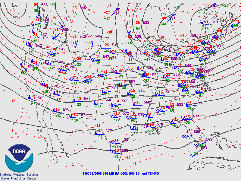
The following 500mb map from 00Z last night (from the Storm Prediction Center) shows rather weak shortwave troughs in the Northwest into the southern Rockies and in eastern Canada, while there’s perhaps a bit of ridging going on in the south central U.S. Not too exciting.

The GFS and NAM models (model observations are based on 00Z runs) do show that the trough in the West will begin to strengthen and dig further south tomorrow. By Monday evening, the models show the trough over Utah with an elongated surface low over northeastern New Mexico and the western Texas Panhandle.
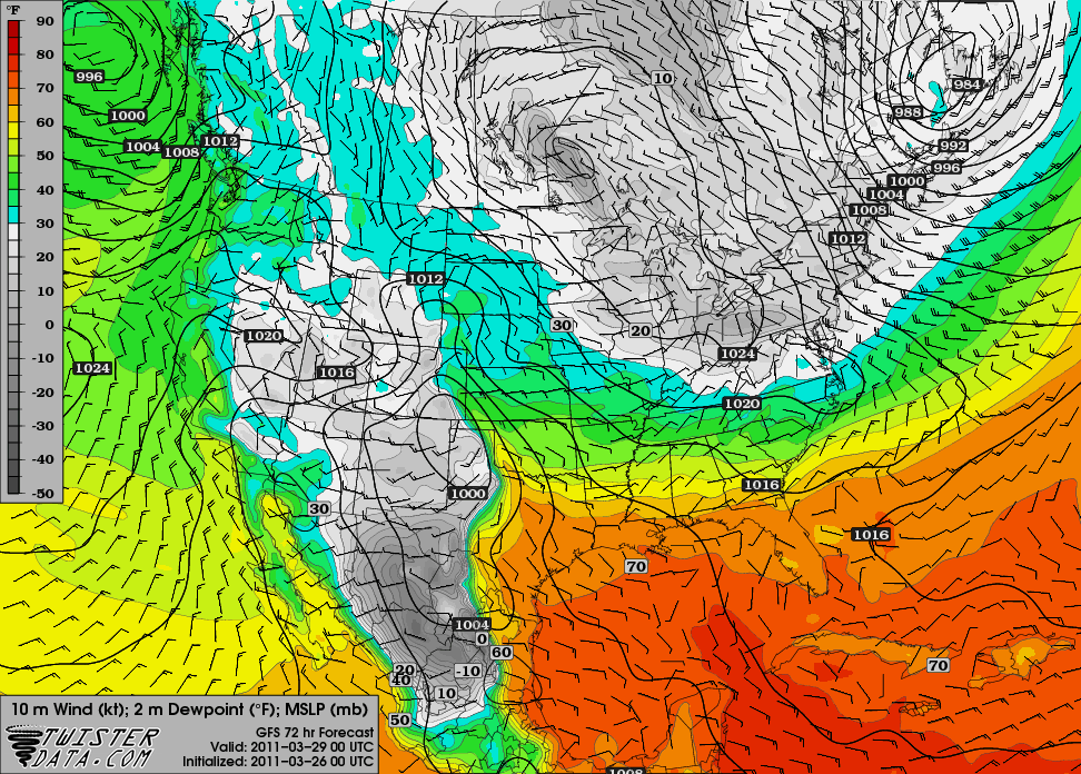
The GFS is a bit more bullish on moisture, as south of the warm front (along the Red River), dewpoints are in the mid- to upper 60s in central into eastern Texas, while the NAM only has these dewpoint values along the Texas Gulf Coast.
The GFS solution for Monday is a bit interesting, but still not enough to tempt me, unless it starts to look better and perhaps sets up a tad further north and west. Also, it looks like the moisture depth will be pretty shallow.

00Z GFS 72-hr forecast for surface pressure and dewpoints, valid 00Z Tuesday (Monday evening), from TwisterData
By Tuesday evening, the GFS shows the trough will have moved on to Missouri. Tuesday may wind up a bigger severe weather day for the lower Mississippi River Valley.
On Wednesday, the GFS indicates another trough may be digging into the southern Rockies, but the model indicates that moisture will be even worse than on Monday, so the chance of storms appears slim at this point.
It also looks like after the Wednesday system, northerly winds will prevent us from getting much moisture return any time soon.
There may be another slim chance or two for severe weather the following week, as some meager moisture may be present in Texas, but it still doesn’t look any good and is too far out to say anyway.
One thing I would bet on, though: I would bet that there will be a good Southern Plains chase day or two (maybe the first outbreak) while I’m in Florida the third week of April. However, I know it won’t bother me as there will always be more tornadoes…but there will only be two more shuttle launches!
Permalink
03.10.11
Posted in General News at 8:00 am by Rebekah
Yesterday I went to a very interesting seminar on the extreme weather events lately in Australia, and how they may be tied to La Niña, natural climate variability, and climate change. I took some notes from the talk and plan on writing up a summary of the seminar for the blog next week.
Today I just want to give you a taste of one of the many projects I’m working on in the lightning research group at OU.
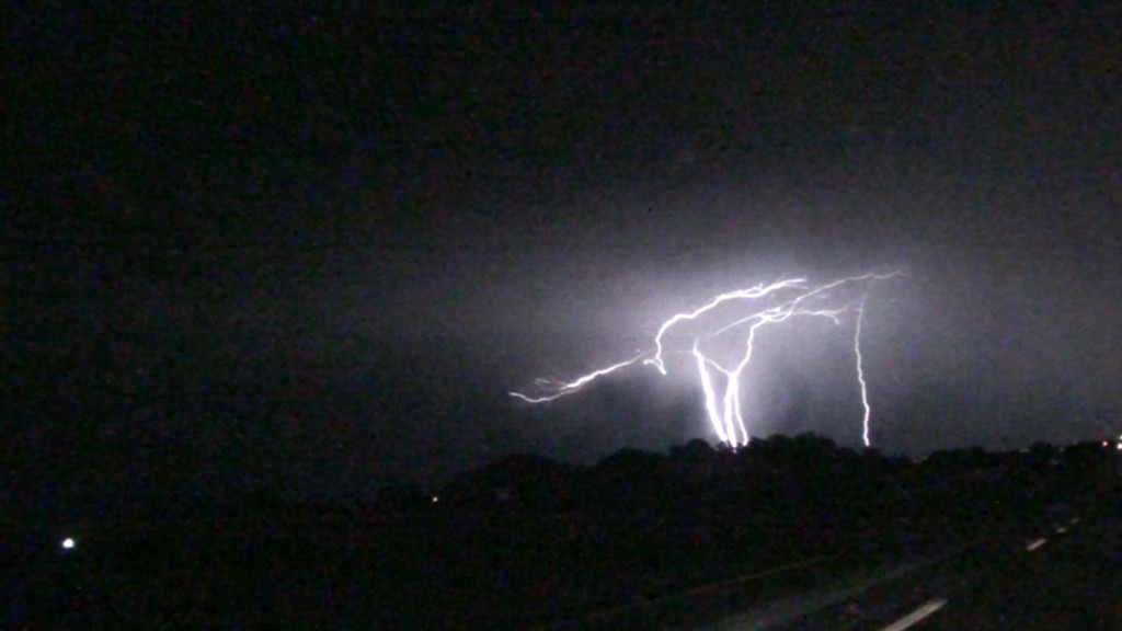
Lately I’ve been analyzing a lightning flash that got my attention last July. While coming back from a chase in northern Oklahoma on July 11th, I saw a lightning stroke that went from the ground to the cloud. I know this type of lightning occurs in areas with tall towers, but I had never seen this with my own eyes before. Now I’m looking at lightning data for the storm and also looking into studying upward-going lightning in other storms, as well as studying up on the literature on the subject as I don’t know much about it.

Captured with my HD camcorder.
Permalink
03.02.11
Posted in Uncategorized at 8:00 am by Rebekah
Yesterday marked the beginning of meteorological spring. This is also about the time when climatologically, tornado season begins to pick up.
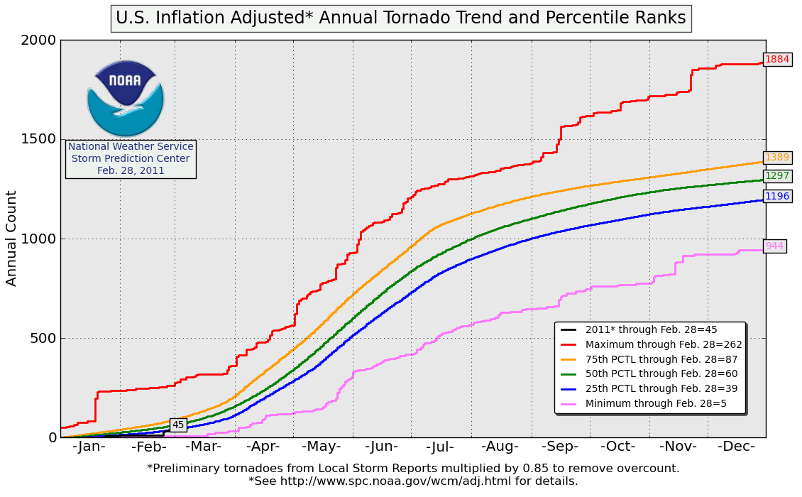
Here are a couple of plots from the Storm Prediction Center, showing where we are so far this year on tornadoes.
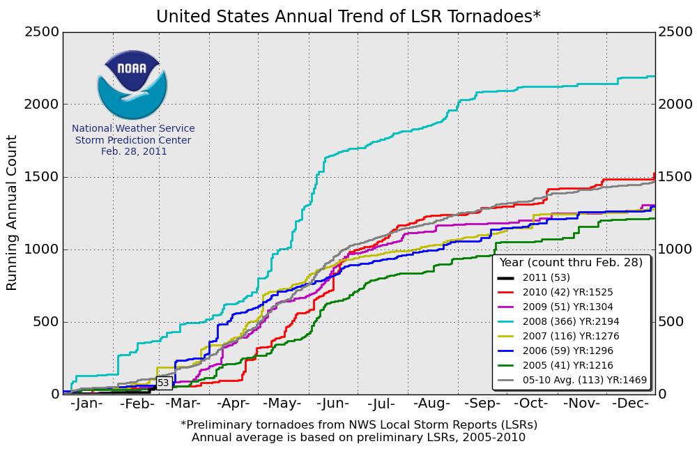
Through the first couple months of the year, there have been 53 tornado reports, which is below the 6-year running average.
The following graph shows the trend in local storm reports (LSR) of tornadoes in the U.S. Values may be a little higher than the actual tornado count (some tornadoes may have been reported more than once). The last six years are shown, as well as the current year up through February 28.

Now look at the graph below (click to enlarge), also from the Storm Prediction Center. This plot shows annual tornado trends; if you’re curious as to how exactly the trends were calculated, see the website on the bottom of the figure. Basically, the red line is the maximum tornado count in a single year and the pink line is the minimum tornado count in a single year. The other lines show tornado trends in quartiles. Currently, 2011 is just above the lowest 25th percentile.

Note the estimated number of tornadoes for 2011 so far is 43 (adjusted downward from the storm reports), though this value is not necessarily the same as the confirmed number of tornadoes.
Permalink
02.28.11
Posted in Uncategorized at 8:00 am by Rebekah

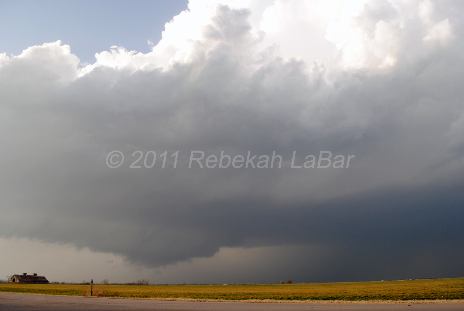
Yesterday we saw a supercell and about three wall clouds in north central Oklahoma, but missed out on the tornadoes this storm later produced, as we gave up just east of Blackwell when the supercell became more outflow dominant and picked up speed. The storm was getting away from us too quickly and we didn’t want to keep following it into worse chase territory (I prefer to stick to chasing west of I-35, as a general rule).
(Special note: this morning’s regularly scheduled weather education post will come later this afternoon.)
Permalink
02.27.11
Posted in Severe Weather Nowcast at 2:37 pm by Rebekah

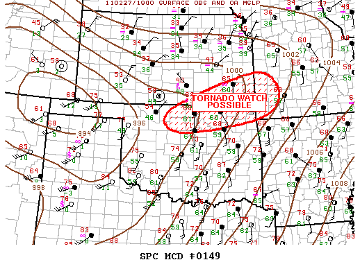
2:12 pm CDT mesoscale discussion graphic from the Storm Prediction Center.
I changed my mind about chasing today, and Jeff and I are on our way up I-35. We’re about 40 miles from Blackwell, Oklahoma, which is around my target area.
There is a nice cumulus field through western Oklahoma, MLCAPE is increasing to above 1500 J/kg in northwest Oklahoma (SBCAPE is above 2500 in western Oklahoma), lapse rates are fairly steep, dewpoints are in the low 60s, and 0 to 6 km bulk shear over much of western and northern Oklahoma is around 60 knots.
A dryline is sharpening in far western Oklahoma, and a warm front is stretching up from southern into eastern Kansas. A surface low is intensifying along the western Kansas/Oklahoma border, in response to a deep shortwave trough heading into the Texas Panhandle.
My expectations are fairly low, but there is a decent chance that there could be a supercell or two up around the Kansas/Oklahoma border late this afternoon. Some elevated storms have already formed along the warm front, but we’re hoping for more surface-based storms closer to the triple point.
Permalink
« Previous Page — « Previous entries « Previous Page · Next Page » Next entries » — Next Page »
